Recorriendo Chile
Resumen del pedido
Tu carro está vacío.
Productos
0
$0
Envío
$0
Total
$0
Calendario 2017
PORTADA
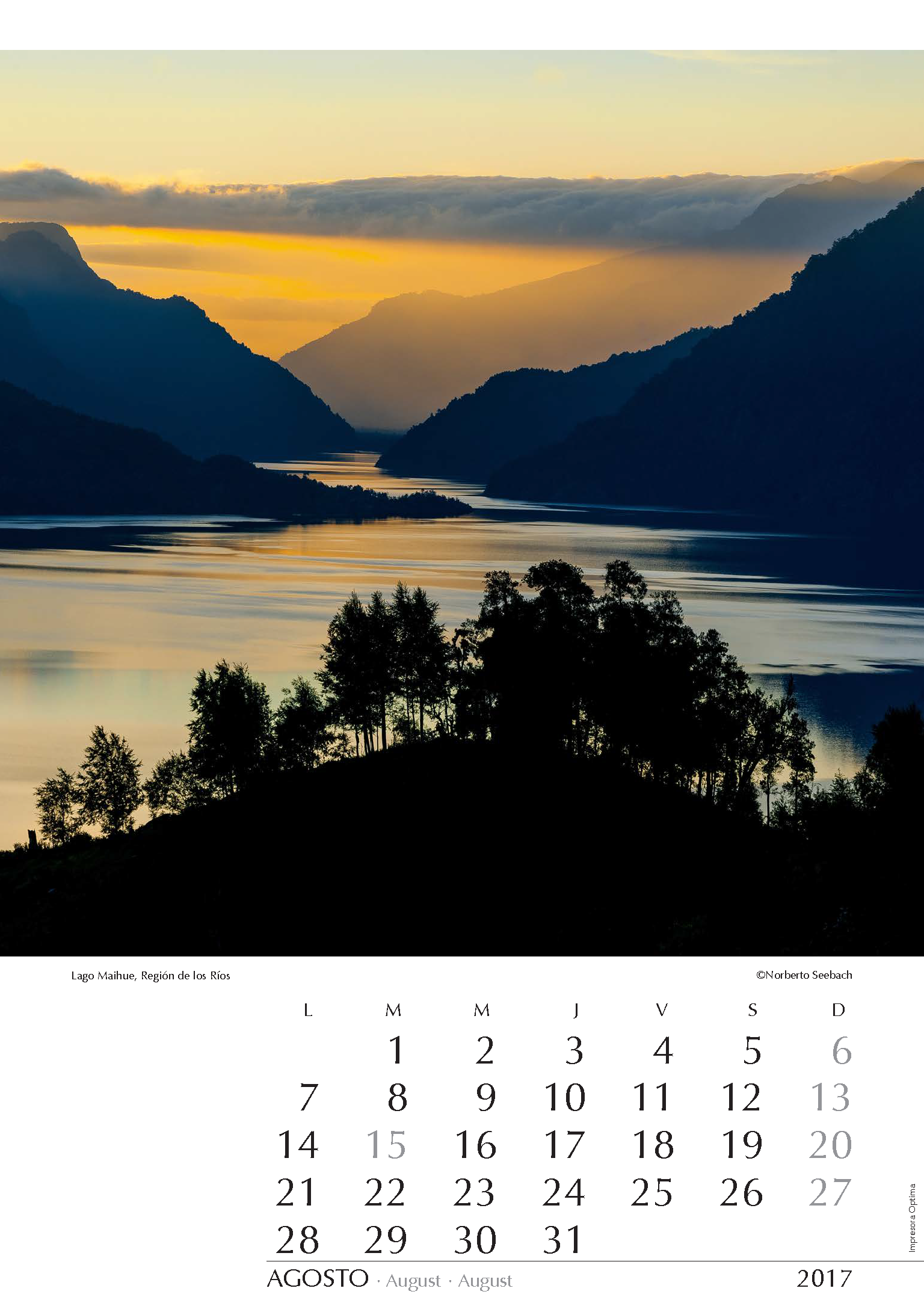
Lago Maihue
Región de los Ríos
La región de lagos, que se inicia en latitud de Temuco, es cada día más accesible por los constantes avances en la infraestructura vial del país. Destaca la red de caminos conocida coma Ruta Interlagos cuyo objetivo es unirlos todos. Un naufragio ocurrido en 2005 presionó además para abrir una ruta por la escarpada ribera norte del pequeño lago Maihue al interior del lago Ranco, para dar conectividad a las reducciones indígenas de ese sector. Distintos miradores ofrecen notables vistas del lago de origen glacial que se extiende de oriente a poniente.
The region of lakes, which starts at latitude of Temuco, is becoming increasingly more accessible as a result of constant advances in the country’s road infrastructure. Especially important is the so-called Ruta Interlagos whose goal is to unite them all. A shipwreck occurred in 2005 also pressed to open a route along the rugged north shore of the small Lago Maihue located to the interior of Lago Ranco in order to provide connectivity to indigenous reductions of that sector. Different lookouts offer remarkable views of the glacial lake that stretches from east to west.
Die Seenregion, die auf der Höhe Temucos beginnt, wird dank der ständigen Verbesserung des Straßennetzes des Landes immer zugänglicher. Erwähnenswert ist die sog. Ruta Interlagos, deren Ziel die Verbindung aller Seen ist. Auf Grund eines Schiffbruchs im Jahr 2005 wurde eine Route entlang des steilen Nordufers des kleinen, östlich des Lago Ranco gelegenen Maihue-Sees gebaut um den Bewohnern von Indianerreservaten dieser Gegend die Zufahrt zu erleichtern. Verschiedene Aussichtspunkte bieten bemerkenswerte Ausblicke auf den durch Gletscher entstandenen, sich von Osten nach Westen erstreckenden See.
ENERO
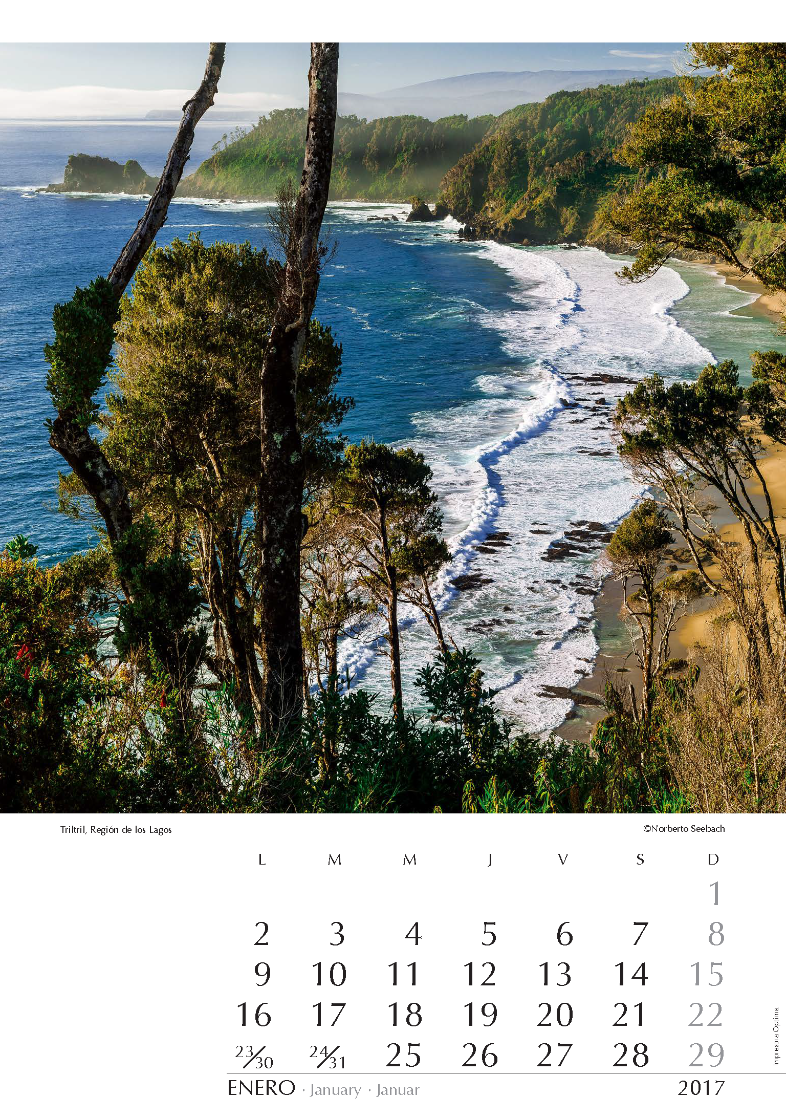
Triltril
Región de los Lagos
Con varios miles de kilómetros de costa, Chile ofrece una variedad difícilmente superable de playas, a menudo solitarias. A unos 60 km al poniente de la ciudad de Osorno y tras pasar por el balneario de Maicolpué, se llega a Triltril, pintoresco caserío encaramado en las serranías junto a una playa azotada por el oleaje del frío Pacífico. La densa vegetación autóctona que decora la Cordillera de la Costa, sobrevive en parte por no continuar hacia el sur la controvertida ruta costera. Enredaderas de copihues adornan los árboles.
With its several thousand miles of coastline, Chile provides a hardly surmountable variety of beaches, often solitary. About 60 km west of the City of Osorno, and after passing the seaside Town of Maicolpué, you can reach the picturesque Hamlet of Triltril. It is perched on the hills close to a beach whipped by the swell of the cold Pacific Ocean. Dense native vegetation decorating the Coastal Range survives in part due to the fact that the controversial road along the coast does not go further south. Creepers with Copihues –Chile’s national flower– adorn the trees.
Mit einigen Tausend Kilometern Küste bietet Chile eine wohl schwer zu übertreffende Vielfalt an oft menschenleeren Stränden. Etwa 60 km westlich von Osorno, und nachdem man den Badeort Maicolpué passiert hat, gelangt man zum pittoresken Triltril, einer Häusergruppe, welche an den Berghängen oberhalb eines vom kalten Pazifik gepeitschten Strandes erbaut wurde. Die dichte Urvegetation, welche die Küstenkordillere hier schmückt, überlebt vor allem weil die umstrittene Küstenstraße nicht weiter südlich führt. Schlingpflanzen der chilenischen Nationalblume Copihue dekorieren die Bäume.
FEBRERO
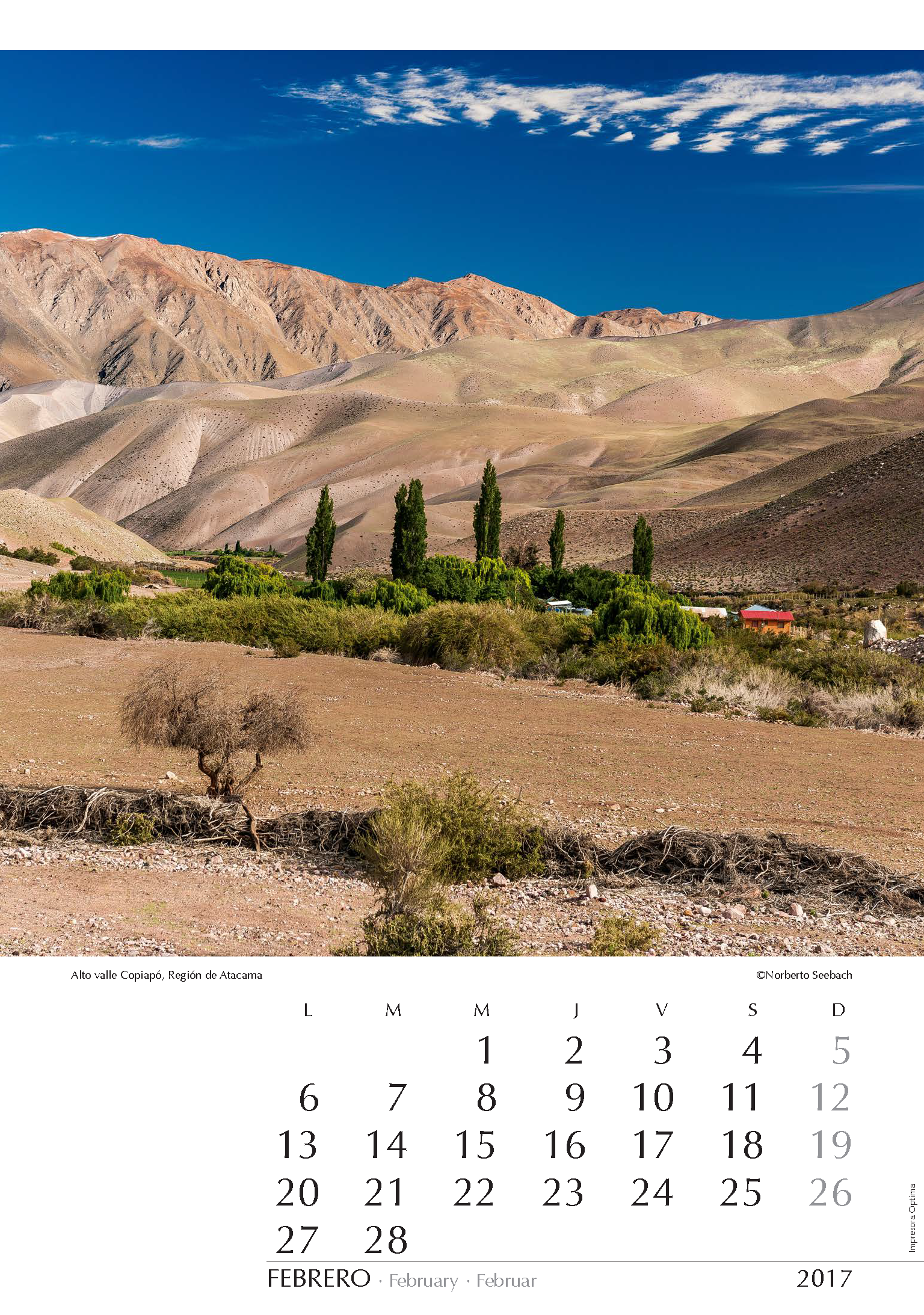
Alto valle Copiapó
Región de Atacama
El río Copiapó marca el término del Norte Grande y comienza así el semidesértico Norte Chico que se vitaliza con los cursos de agua que, provenientes del macizo andino, surcan los valles transversales. A unos 150 km al sureste de la capital de Atacama, está el río del Potro cuyo caudal aporta a la maraña de ríos tributarios del Copiapó. Su modesto caudal alimenta la exigua vegetación de pastizales, matorrales, sauces y los infaltables álamos, tan característicos del campo chileno. Impresiona el contraste entre el verdor y el desierto circundante.
Río Copiapó marks the end of the so-called Norte Grande. Here begins the semidesert area of the “Norte Chico” vitalized with the rivers which, originating in the Andean Range, meander through the transversal valleys. About 150 km southeast of Copiapó, capital of the Atacama Region, is Río Potro whose waters also feed the tangle of Copiapó River tributaries. Its scarce flow gives life to the exiguous vegetation of grasslands, shrubs, willows and the ever-present poplars that characterize the Chilean landscape. The contrast of the greenness with the surrounding desert impresses.
Der Río Copiapó markiert das Ende des sog. Norte Grande. Es beginnt so die durch Halbwüste geprägte Landschaft des “Norte Chico” welche durch die in der Andenkette entstehenden Bäche belebt wird. Etwa 150 km südöstlich von Copiapó, der Hauptstadt Atacamas, ist der Río Potro dessen Wasser zum Wirrwarr von Nebenflüssen des Copiapó beiträgt. Weideland, Gebüsch, Trauerweiden und die allgegenwärtigen Pappeln, welche Chiles Landschaftsbild charakterisieren, verdanken diesem Rinnsal ihr Leben. Der Kontrast zwischen dem Grün und der umgebenden Wüste beeindruckt.
MARZO
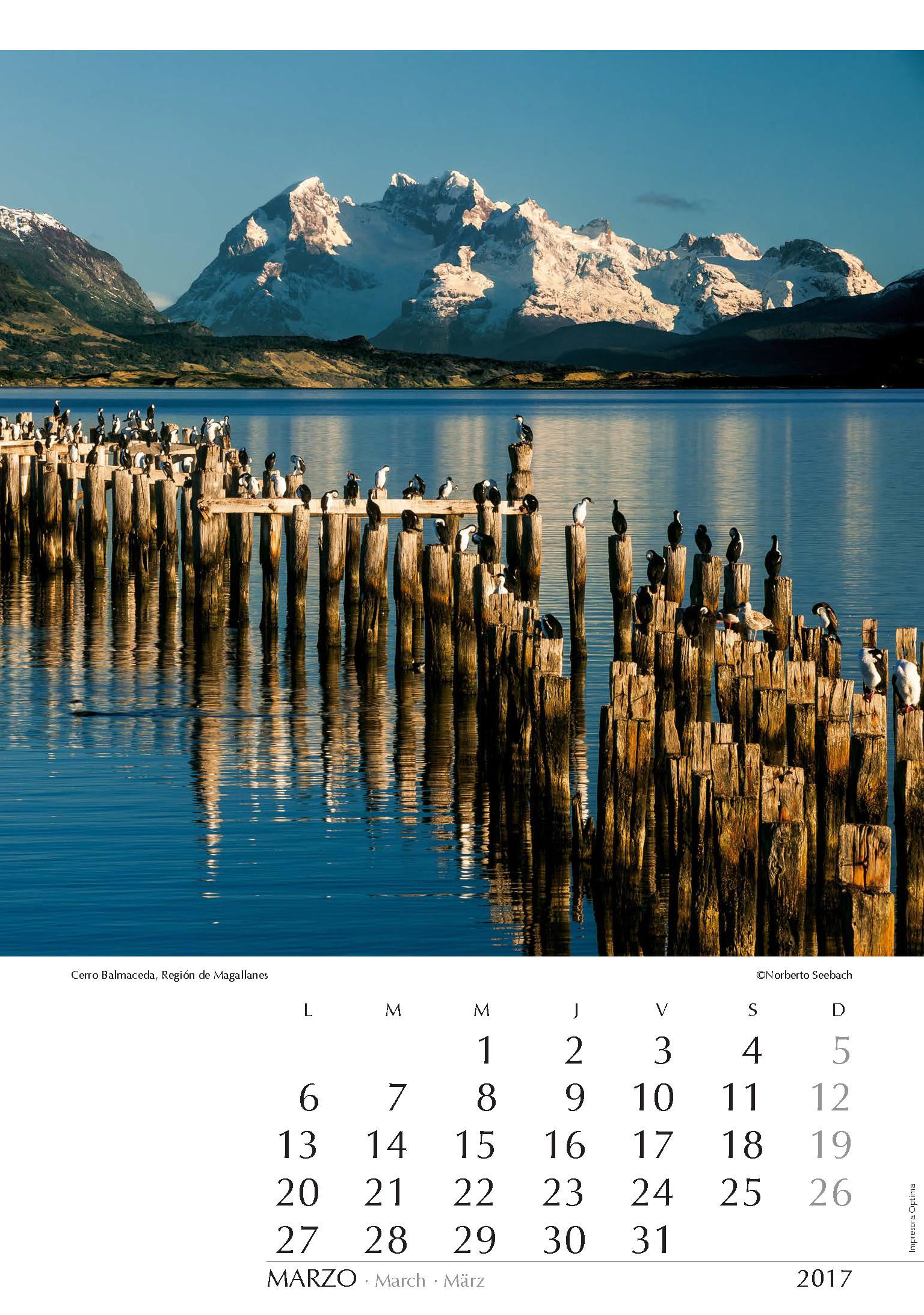
Cerro Balmaceda
Región de Magallanes
Hito turístico en la costanera de Puerto Natales es el antiguo muelle en cuya destartalada estructura estos cormoranes disfrutan de un amanecer otoñal. Alrededor de tres horas de navegación por el seno Última Esperanza, separan este lugar de la base del cerro Balmaceda (2035 m). Dicho macizo se localiza en el extremo austral del Hielo Patagónico Sur y de él descienden dos conocidos glaciares que constituyen el foco de atención de quienes hasta ahí llegan: el Balmaceda y el Serrano. Remontando el río Serrano que en aquel lugar desemboca, se puede también acceder por agua al Parque Nacional Torres del Paine.
A tourist landmark on the coastal promenade of Puerto Natales is the old pier in whose ruined structure these cormorants enjoy an autumn dawn. Navigating for about three hours along the Última Esperanza Fjord, one gets to the base of Cerro Balmaceda (2035 m) at the south end of Hielo Patagónico Sur. Two wellknown glaciers are the highlights for those visiting this zone: Balmaceda and Serrano. Going up through the waters of Río Serrano, emptying into the fjord at that place, Torres del Paine National Park can also be accessed.
Touristisches Wahrzeichen an der Küstenpromenade von Puerto Natales ist die zerfallene alte Mole, in der diese Kormorane eine Herbstdämmerung genießen. Von hier aus kann man nach einer etwa dreistündigen Bootsfahrt durch den Última Esperanza Fjord den Fuß des Cerro Balmaceda (2035 m) am Südende des Südlichen Patagonischen Eises erreichen. Zwei berühmte Gletscher sind das Ziel der Besucher: Balmaceda und Serrano. Durch den dort ins Meer mündenden Río Serrano kann man auch bis zum Nationalpark Torres del Paine gelangen.
ABRIL
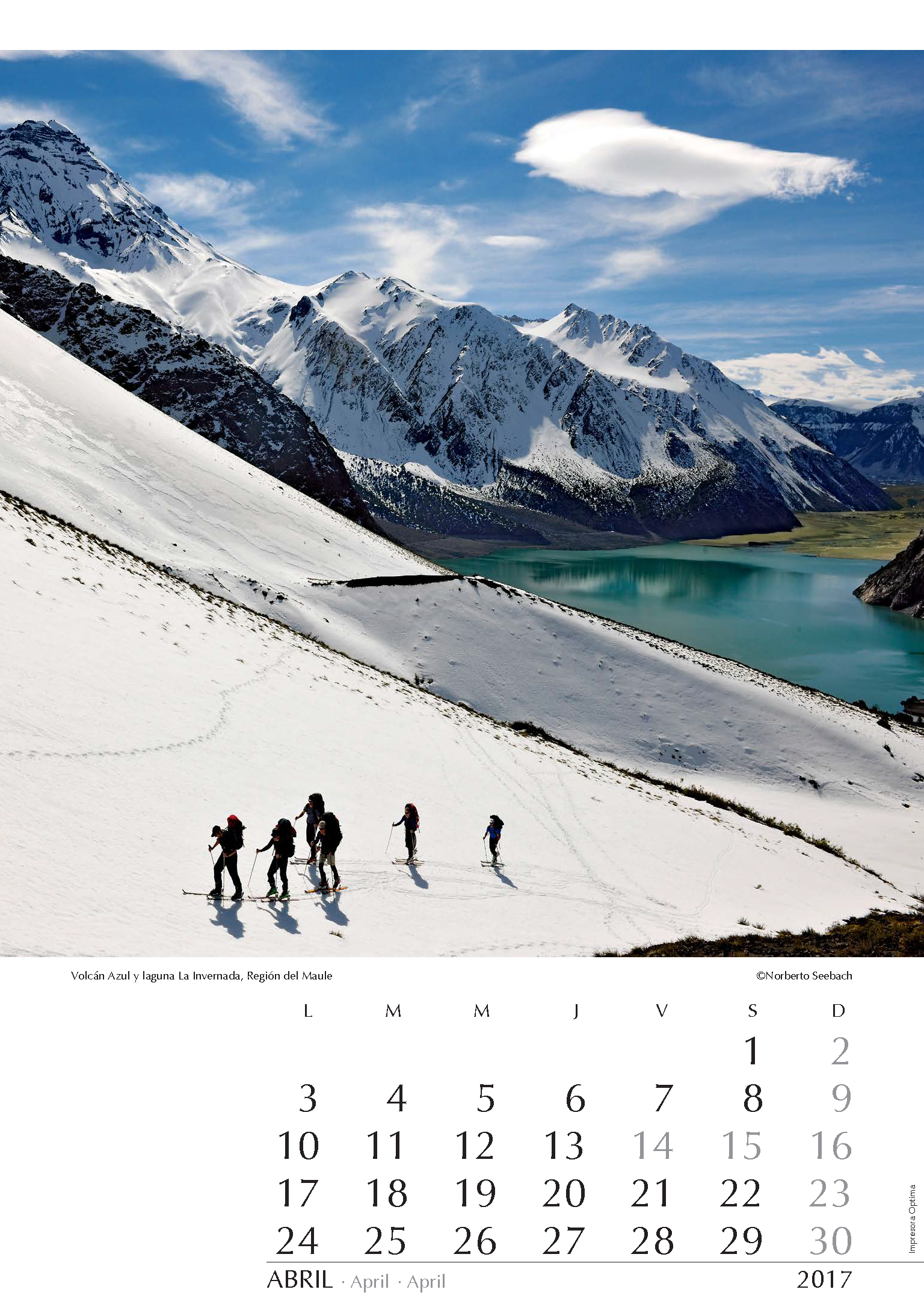
Volcán Azul y laguna La Invernada
Región del Maule
Una constante en la Cordillera de los Andes son sus volcanes. En plena zona central, unos 250 km al sur de Santiago, al oriente de Talca, se destacan varios. Particularmente imponente es el conglomerado volcánico formado por el Descabezado Grande, Quizapu y Azul. Ceniza, lava y arena cubren un vasto territorio al norte del río Maule. Desde la vertiente sur de los referidos volcanes, un grupo de montañistas inicia una ascensión invernal a la cumbre del volcán Azul (3800 m). Punto de partida es la laguna La Invernada que aquí se muestra.
Volcanoes are always present along the Andean Range. In Central Chile, 250 km to the south of Santiago and to the east of Talca, several may be distinguished. A chaotic area of lava and pumice, the result of eruptions from Descabezado Grande, Quizapu and Azul volcanoes, characterizes vast territories north of the Maule River. From the south side of the aforementioned volcanoes a group of mountaineers initiate a winter summit ascent of Volcán Azul (3800 m). A starting point is the La Invernada lagoon shown here.
Vulkane trifft man überall in den Anden an. In der Zentralzone,
250 km südlich von Santiago, finden sich östlich von Talca einige bemerkenswerte Gipfel. Nördlich des Río Maule entstand in Folge von Ausbrüchen der Vulkane Descabezado Grande, Quizapu und Azul eine öde Landschaft aus Lava und Bimsstein. Von der Südseite der genannten Vulkane aus beginnt eine Gruppe von Bergsteigern einen Winteraufstieg zum Gipfel des Volcán Azul (3800 m). Ausgangspunkt ist der hier abgebildete See La Invernada.
MAYO
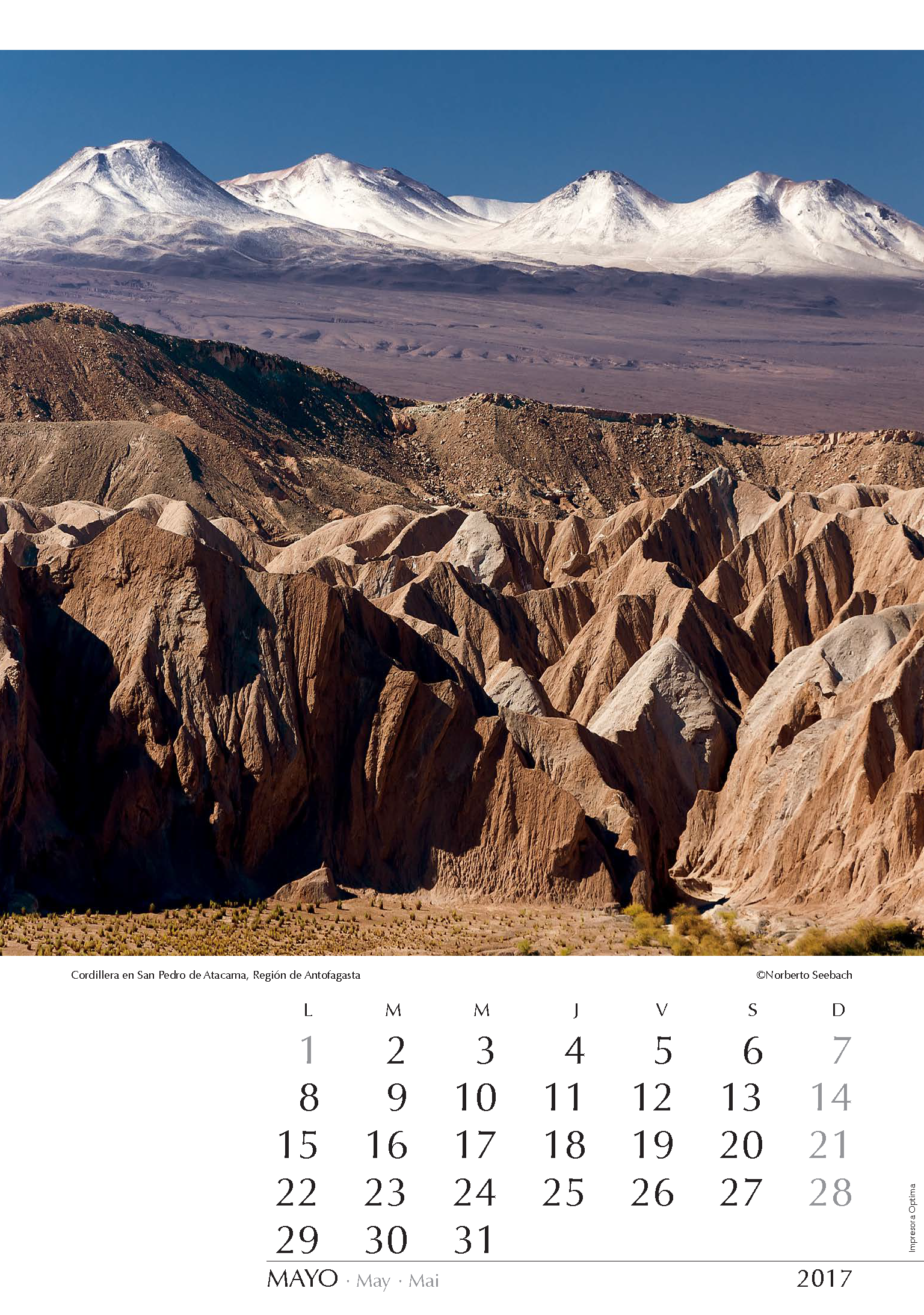
Cordillera en San Pedro de Atacama
Región de Antofagasta
No sólo geólogos y vulcanólogos se deleitan con las caprichosas serranías del entorno de San Pedro de Atacama. Desde la Cordillera de la Sal, que flanquea por el poniente el valle del río San Pedro, se observan curiosos pliegues del erosionado cordón en su margen oriental, y en segundo plano aparecen las cumbres volcánicas del concatenamiento principal del macizo andino. Justo en aquel sector está el llano de Chajnantor que alberga al Parque Astronómico de Atacama, cuyos grandes proyectos astronómicos en pleno desarrollo permitirán a Chile ser el tal vez más importante referente en dicha ciencia.
Not only geologists and volcanologists delight in the whimsical mountainous environment of San Pedro de Atacama. From the Cordillera de la Sal, flanking on the west the valley of San Pedro River, curious folds of an eroded mountain range can be observed in its eastern margin while in the background appear volcanic peaks in the main concatenation of the Andean Range. Exactly in that sector is the Plain of Chajnantor that houses the Astronomical Park Atacama, whose large astronomical projects under development will allow Chile to be perhaps the most important benchmark in this science.
Nicht nur Geologen und Vulkanologen erfreuen sich an der skurrilen bergigen Umgebung von San Pedro de Atacama. Von der Cordillera de la Sal aus, die das Tal des Río San Pedro im Westen abgrenzt, blickt man auf merkwürdige Falten eines erodierten Gebirgszuges des Ostufers während im Hintergrund vulkanische Gipfel aus dem Hauptkamm der Anden herausragen. Gerade in jenem Abschnitt, in der Ebene von Chajnantor, wurde der Astronomische Park Atacama geschaffen, um große astronomische Projekte, die teils in voller Entwicklung sind, zu beherbergen. Dadurch wird Chile wohl zu den wichtigsten Zentren dieser Wissenschaft gehören.
JUNIO
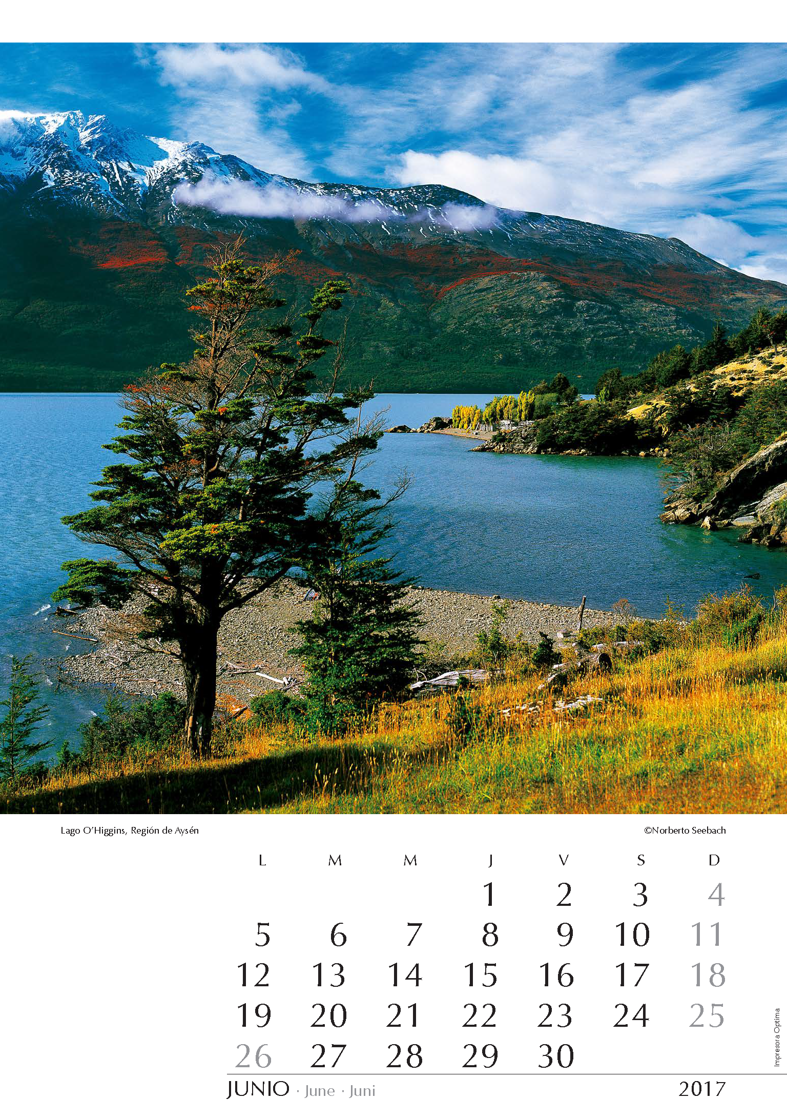
Lago O’Higgins
Región de Aysén
Con una superficie que supera los 1000 km2, el lago O’Higgins es uno de los grandes lagos que comparten Chile y Argentina (donde se llama San Martín). Mirando un mapa, se comprende la en extremo confusa geografía de esta zona del sur de Aysén próxima al Campo de Hielo Sur y a los fiordos de la Patagonia occidental. Cerca del lugar de esta toma concluyen los caminos anexos a la Carretera Austral, y la continuación hacia el sur debe realizarse navegando por un brazo del lago por cuyo centro va la línea fronteriza que separa de Argentina. El cordón nevado que en las alturas luce una hermosa coloración otoñal, está ya en el vecino país.
With an area of over 1000 km2 Lago O’Higgins is one of the great lakes shared by Chile and Argentina (where it is called San Martín). Looking at a map, one can realize the extremely confusing geography of this zone in the south of the Aysén Region next to the Southern Patagonian Ice Field and the fjords of Western Patagonia. Near the pictured site, conclude the roads annexed to the Carretera Austral and an advance towards south must be done navigating along one arm of the lake in whose center is the borderline to Argentina. The snow-covered mountain range showing beautiful autumn coloring in the heights is already in the neighboring country.
Mit einer Fläche von mehr als 1000 km2 ist der Lago O’Higgins, einer der großen Seen, die Chile und Argentinien teilen (dort wird er San Martin genannt). Ein Blick auf die Karte zeigt, wie verworren die Geographie in diesem Gebiet im Süden der Region Aysén, in der Nähe des Südlichen Patagonischen Eises und der Fjorde Westpatagoniens, ist. Unweit des Standorts dieser Aufnahme enden die letzten Nebenwege der Carretera Austral und, um weiter südlich zu gelangen ist die Navigation entlang eines Armes des Sees, durch dessen Mitte die Grenze verläuft, erforderlich. Der schneebedeckte, in höheren Lagen in Herbstfarben leuchtende Gebirgszug, ist bereits im Nachbarland.
JULIO
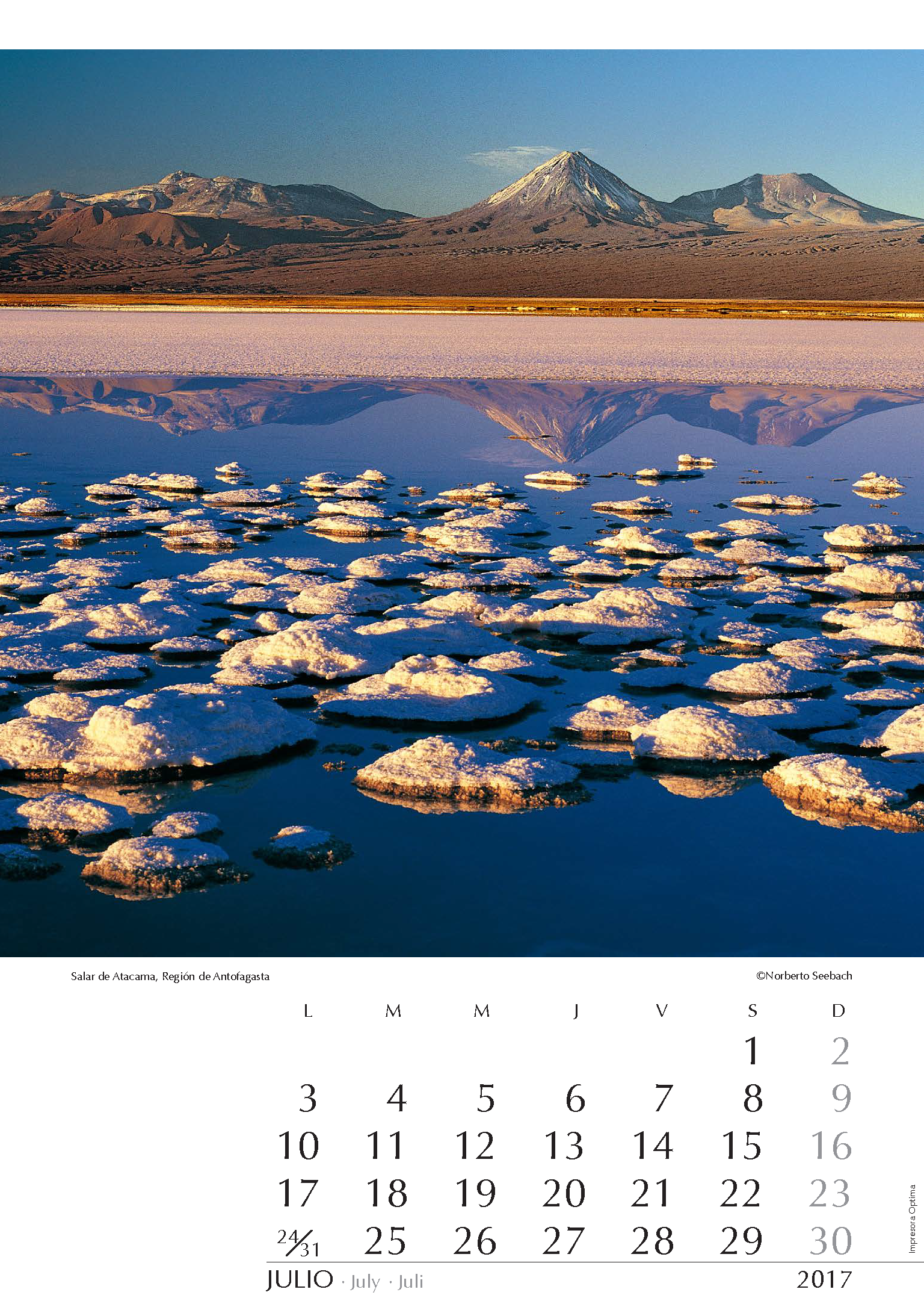
Salar de Atacama
Región de Antofagasta
El enorme salar de Atacama cubre un área cercana a los 3000 km2. Se nutre por un sinnúmero de vertientes que descienden de manera intermitente desde el macizo andino. Diversas lagunas afloran en la costra salada. Como en el mar Muerto, es posible flotar en la laguna Céjar, ubicada unos 20 km al sur de San Pedro de Atacama. A poca distancia está Tebinquiche, desde cuya ribera se ve al oriente el volcán Licancabur (5920 m), ubicado en la frontera con Bolivia y que antaño fue centro de rituales y ceremonias de los pueblos originarios. A su derecha está el volcán Juriques (5700 m).
The vast Salar de Atacama covers an area of around 3000 km2. It is nourished by countless streams that descend intermittently from the Andean massif. Various gaps emerge in the salt crust. As in the Dead Sea, you can float in the Laguna Céjar, located about 20 km south of San Pedro de Atacama. A short distance away stands Tebinquiche from whose shore you can see to the east Volcán Licancabur (5920 m) on the border with Bolivia and which was once the center of rituals and ceremonies of indigenous peoples.To the right is Volcán Juriques (5700 m).
Mit rund 3000 Quadratkilometern ist der enorme Salar de Atacama etwa sechsmal so groß wie der Bodensee. Er wird genährt von einer Vielzahl oft nur sporadisch fließender Rinnsale, die von der Andenkette herabkommen. Verschiedene Lagunen unterbrechen die Salzkruste: wie im Toten Meer kann man sich vom Salzwasser der etwa 20 km südlich von San Pedro de Atacama gelegenen Laguna Céjar tragen lassen. Unweit ist Tebinquiche von dessen Ufer aus man in östlicher Richtung auf den auf der Grenze zu Bolivien gelegenen, 5920 m hohen Vulkan Licancabur, einst Kultstätte der Ureinwohner, blicken kann. Rechts erscheint der Vulkan Juriques (5700 m).
AGOSTO
Lago Maihue
Región de los Ríos
La región de lagos, que se inicia en latitud de Temuco, es cada día más accesible por los constantes avances en la infraestructura vial del país. Destaca la red de caminos conocida coma Ruta Interlagos cuyo objetivo es unirlos todos. Un naufragio ocurrido en 2005 presionó además para abrir una ruta por la escarpada ribera norte del pequeño lago Maihue al interior del lago Ranco, para dar conectividad a las reducciones indígenas de ese sector. Distintos miradores ofrecen notables vistas del lago de origen glacial que se extiende de oriente a poniente.
The region of lakes, which starts at latitude of Temuco, is becoming increasingly more accessible as a result of constant advances in the country’s road infrastructure. Especially important is the so-called Ruta Interlagos whose goal is to unite them all. A shipwreck occurred in 2005 also pressed to open a route along the rugged north shore of the small Lago Maihue located to the interior of Lago Ranco in order to provide connectivity to indigenous reductions of that sector. Different lookouts offer remarkable views of the glacial lake that stretches from east to west.
Die Seenregion, die auf der Höhe Temucos beginnt, wird dank der ständigen Verbesserung des Straßennetzes des Landes immer zugänglicher. Erwähnenswert ist die sog. Ruta Interlagos, deren Ziel die Verbindung aller Seen ist. Auf Grund eines Schiffbruchs im Jahr 2005 wurde eine Route entlang des steilen Nordufers des kleinen, östlich des Lago Ranco gelegenen Maihue-Sees gebaut um den Bewohnern von Indianerreservaten dieser Gegend die Zufahrt zu erleichtern. Verschiedene Aussichtspunkte bieten bemerkenswerte Ausblicke auf den durch Gletscher entstandenen, sich von Osten nach Westen erstreckenden See.
La región de lagos, que se inicia en latitud de Temuco, es cada día más accesible por los constantes avances en la infraestructura vial del país. Destaca la red de caminos conocida coma Ruta Interlagos cuyo objetivo es unirlos todos. Un naufragio ocurrido en 2005 presionó además para abrir una ruta por la escarpada ribera norte del pequeño lago Maihue al interior del lago Ranco, para dar conectividad a las reducciones indígenas de ese sector. Distintos miradores ofrecen notables vistas del lago de origen glacial que se extiende de oriente a poniente.
The region of lakes, which starts at latitude of Temuco, is becoming increasingly more accessible as a result of constant advances in the country’s road infrastructure. Especially important is the so-called Ruta Interlagos whose goal is to unite them all. A shipwreck occurred in 2005 also pressed to open a route along the rugged north shore of the small Lago Maihue located to the interior of Lago Ranco in order to provide connectivity to indigenous reductions of that sector. Different lookouts offer remarkable views of the glacial lake that stretches from east to west.
Die Seenregion, die auf der Höhe Temucos beginnt, wird dank der ständigen Verbesserung des Straßennetzes des Landes immer zugänglicher. Erwähnenswert ist die sog. Ruta Interlagos, deren Ziel die Verbindung aller Seen ist. Auf Grund eines Schiffbruchs im Jahr 2005 wurde eine Route entlang des steilen Nordufers des kleinen, östlich des Lago Ranco gelegenen Maihue-Sees gebaut um den Bewohnern von Indianerreservaten dieser Gegend die Zufahrt zu erleichtern. Verschiedene Aussichtspunkte bieten bemerkenswerte Ausblicke auf den durch Gletscher entstandenen, sich von Osten nach Westen erstreckenden See.
SEPTIEMBRE
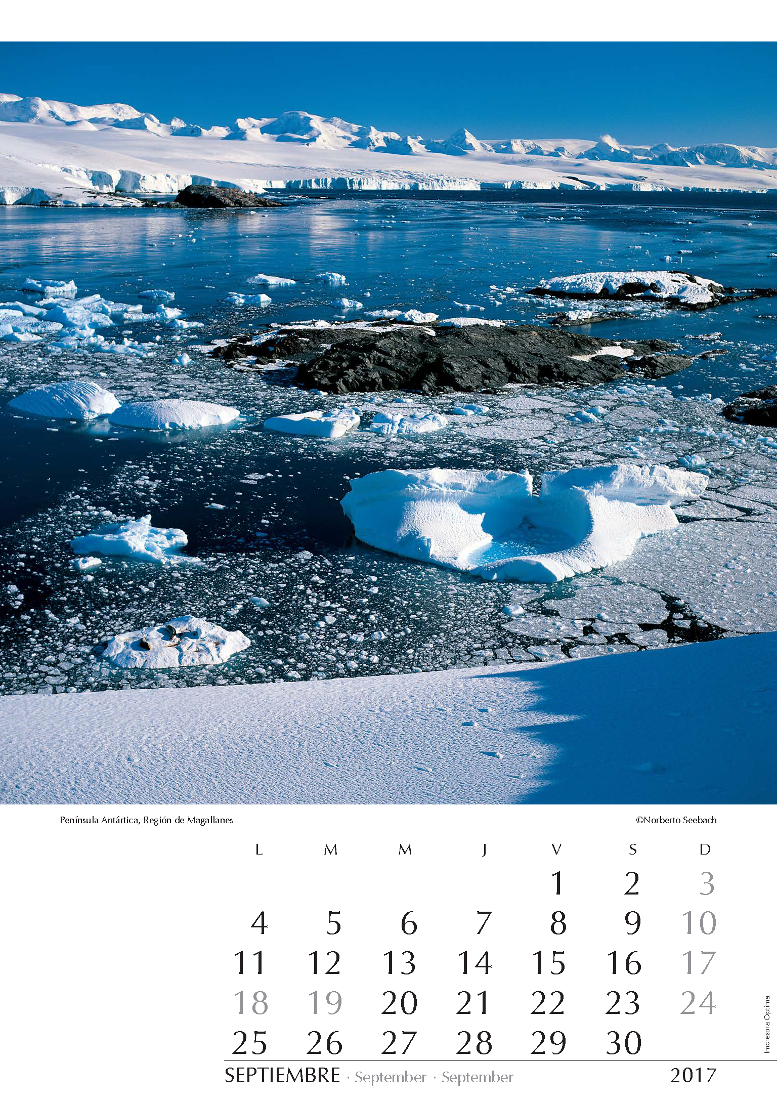
Península Antártica
Región de Magallanes
Chile es uno de los primeros países que ya en 1961 suscribió el Tratado Antártico y además mantiene –junto a Argentina y al Reino Unido– reclamaciones territoriales sobre estos espectaculares escenarios del continente más alto, más seco y más frío del planeta y que constituyen un patrimonio de toda la humanidad. En la península antártica, conocida en Chile como Tierra de O’Higgins, el Ejército administra desde 1948 la base O’Higgins. Desde las cercanías de la base se tiene esta vista de la inmensidad de los gélidos territorios que se extienden al suroeste de ella.
Chile is one of the first countries signing the Antarctic Treaty and maintains – together with Argentina and the United Kingdom– territorial claims on these spectacular landscapes on the coldest, highest and driest continent whose unpolluted beauty should be kept for the whole world community. On the Antarctic Peninsula, known in Chile as Tierra de O’Higgins, the Army has been administrating Base O’Higgins since 1948. Close to the base, one has this view of the vastness of the frozen territories stretching southwest from here.
Chile ist Gründerstaat des
Antarktisabkommens und beansprucht –nebst Argentinien und Großbritannien– Teile des Territoriums dieser spektakulären Landschaft des kältesten, höchsten und trockensten Kontinents, deren unberührte Schönheit der gesamten Menschheit erhalten bleiben sollte. Auf der antarktischen Halbinsel, in Chile Tierra de O’Higgins genannt, verwaltet das Heer seit 1948 die Basis O’Higgins. In deren Nähe hat man diese Ausssicht auf die immensen eisbedeckten Gebiete, die sich in südwestlicher Richtung erstrecken.
OCTUBRE
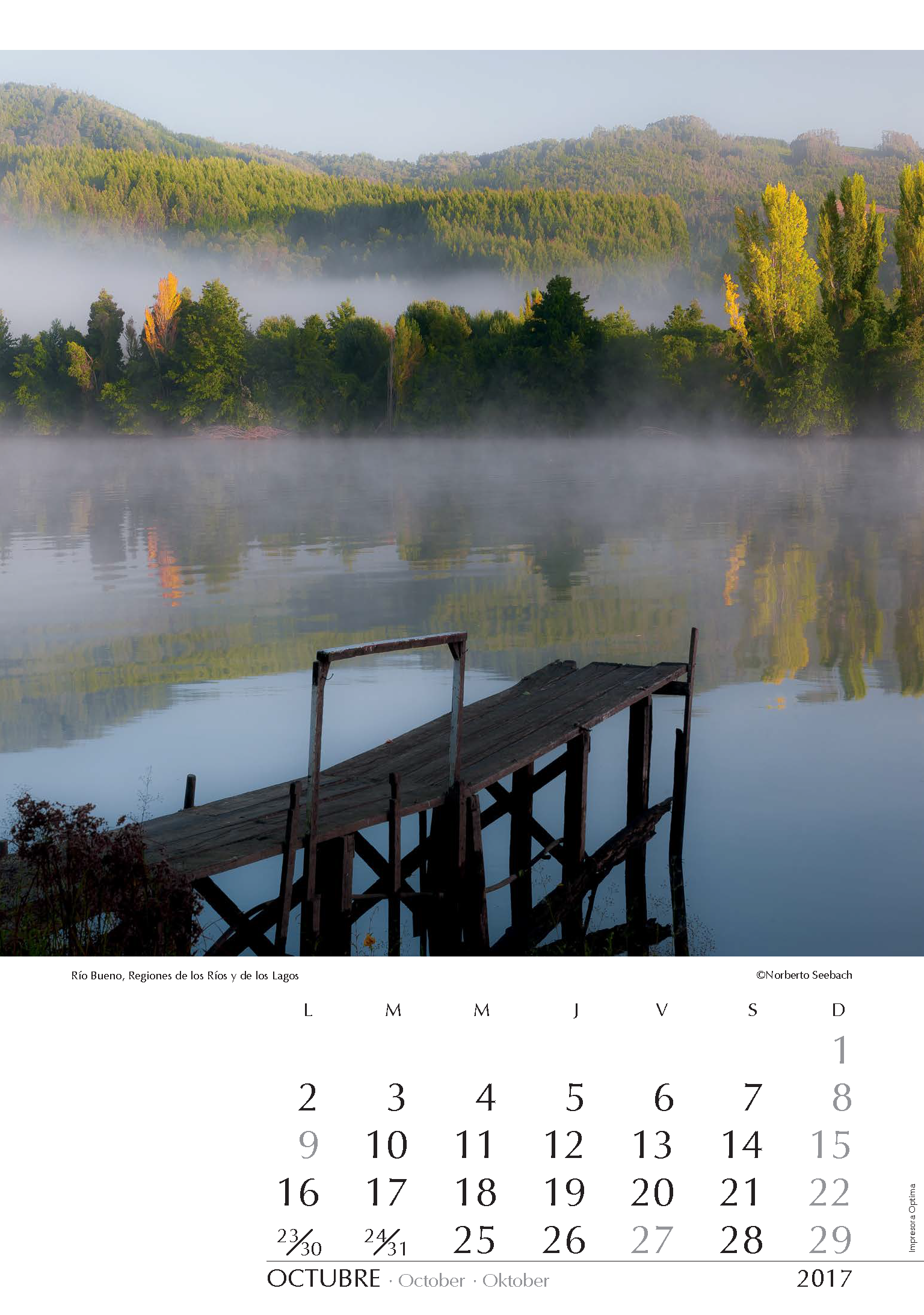
Río Bueno
Regiones de los Ríos y de los Lagos
Caudalosos ríos marcan el paisaje del sur del país. Con una cuenca, que en área supera los 15mil km2, el río Bueno, que se origina en el lago Ranco desde donde recorre 130 km hasta alcanzar el Pacífico, recolecta aguas de un sinnúmero de lagos, entre otros el Rupanco y el Puyehue. Es navegable entre La Unión (Trumao) y su desembocadura en “La Barra”. Diversos asentamientos en este sector sólo son alcanzables por esta vía. Antaño, navíos ingresaban desde el mar, cuestión que hoy impide la arena embancada en su desembocadura. En el lugar que se muestra, el río es además límite interregional.
Plentiful rivers mark the southern Chilean landscape. With a basin exceeding an area of 15 thousand km2, Río Bueno, originating at Lago Ranco from where it meanders for 130 km until it reaches the Pacific, collects waters from countless lakes, including the Rupanco and the Puyehue. It is navigable between La Unión (Trumao) and its mouth in “La Barra”. Various settlements in this sector are only achievable by this route. Yesteryear boats entered from the sea but nowadays the silted river’s mouth prevents this. In the place shown, the river is also an interregional limit.
Wasserreiche Flüsse prägen die Landschaft Südchiles. Mit einem Becken von mehr als 15 Tausend km2 Fläche erreicht der am Lago Ranco entstehende Río Bueno nach 130 km den Pazifik und sammelt auf seinem Lauf das Wasser unzähliger Seen, darunter der Puyehue und der Rupanco. Er ist zwischen La Unión (Trumao) und seiner Mündung in “La Barra” schiffbar. Verschiedene Siedlungen in diesem Sektor sind nur auf diesem Wege erreichbar. Einst konnten vom Meer aus Schiffe in den Fluss fahren, die versandete Mündung verhindert es heutzutage. Am abgebildeten Ort ist der Fluss zugleich interregionale Grenze.
NOVIEMBRE
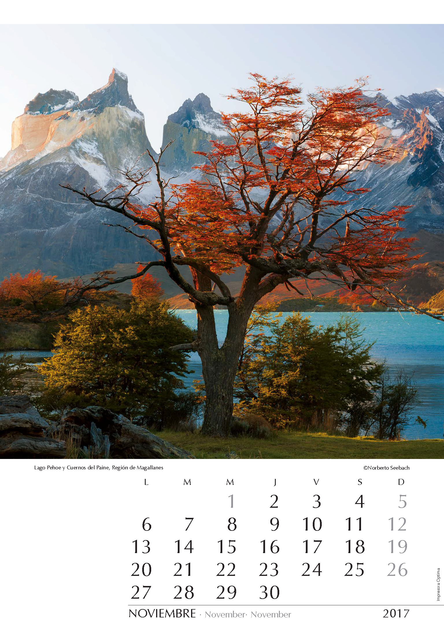
Lago Pehoe y Cuernos del Paine
Región de Magallanes
Quienes visitan por primera vez el Parque Nacional Torres del Paine no sólo se sorprenden con la espectacular escenografía que ofrece, también les dificulta su enmarañada geografía de lagos, glaciares, montañas, bosques y ríos. Es así como con frecuencia se confunden también Las Torres y Los Cuernos, atractivas y representativas cumbres del parque que desafían a montañistas de todo el mundo. Los Cuernos se ven aquí desde la orilla del lago Pehoe junto a la colorida vegetación que denota el inicio del otoño.
Those visiting Torres del Paine National Park for the first time are not only surprised by the spectacular scenery offered, but also have problems with the tangled geography of lakes, glaciers, mountains, forests and rivers. This is how one often confuses Las Torres (= towers) and Los Cuernos (= horns), attractive and representative peaks of the park, a challenge for climbers from all over the world. Los Cuernos appear here captured from the shore of Lake Pehoe with colorful vegetation that denotes the beginning of autumn.
Alle, die zum ersten Mal den Nationalpark Torres del Paine besuchen, sind nicht nur von der überwältigenden Landschaft überrascht, sie haben auch Mühe mit der verwirrenden Geographie von Seen, Gletschern, Bergen, Wäldern und Flüssen. So kommt es auch, dass oftmals die Torres (= Türme) und Cuernos (= Hörner), beide attraktive und repräsentative Gipfel und Herausforderung für Bergsteiger aus aller Welt, verwechselt werden. Die Cuernos sind hier vom Ufer des Sees Pehoe aus zu sehen, die farbenreiche Vegetation deutet auf den Beginn des Herbstes hin.
DICIEMBRE
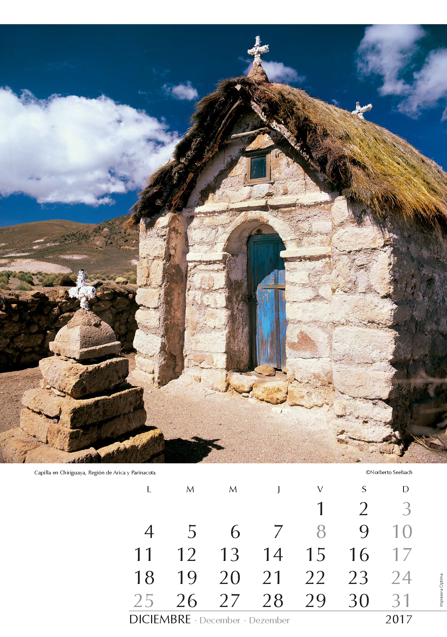
Capilla en Chiriguaya
Región de Arica y Parinacota
Al recorrer el Altiplano nortino se observa una abundancia de pequeños poblados y una notable ausencia de moradores en los mismos. Muchos de ellos han emigrado a las grandes ciudades y sólo regresan para las festividades religiosas en sus villorrios de origen. En los faldeos del volcán Guallatire, al interior de Arica, se localizan las termas y también el caserío de Chiriguaya (tb. Churiguaya). Muestra del fervor religioso es la modesta capilla labrada con piedras y materiales del entorno, que decora el paisaje a 4800 m de altitud.
Travelling through the northern Chilean Altiplano, one can see numerous hamlets and a notable absence of inhabitants in them. Many of them have immigrated to big cities and they only return to attend the religious festivals in their native villages. On the slopes of the Volcano of Guallatire, within Arica, the hot springs and the Hamlet of Chiriguaya (or Churiguaya) are located. A demonstration of the religious fervor is the modest chapel sculptured from stones and materials from the environment, decorating the landscape at 4800 m above sea level.
Bereist man das Andenhochland im Norden Chiles, stößt man auf eine Vielzahl von Ortschaften, die aber oft menschenleer sind. Die Bewohner sind meist in die Städte ausgewandert und kehren nur zu religiösen Festen in ihre Dörfer zurück. An den Hängen des Vulkans Guallatire, in den Hochanden bei Arica, stößt man auf die Thermalquellen und den gleichgenannten Weiler Chiriguaya (auch Churiguaya). Zeichen der religiösen Inbrunst ist die kleine Kapelle, welche aus Stein und Materialien aus der Umgebung geschaffen wurde und welche diese Landschaft auf 4800 m über dem Meeresspiegel schmückt.