Recorriendo Chile
Resumen del pedido
Tu carro está vacío.
Productos
0
$0
Envío
$0
Total
$0
Calendario 2020
PORTADA
Camino a Yendegaia
Región de Magallanes
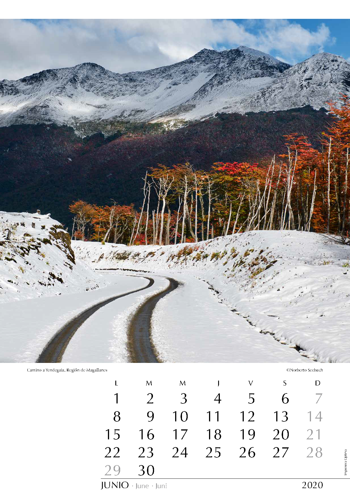
La isla grande de Tierra del Fuego, compartida con Argentina, es sinónimo de grandes aventuras, de tierras extensas e inhóspitas. En 1920, a ambos lados de la frontera había igual cantidad de habitantes; hoy la relación es de 1 (Chile) a 20 (Argentina). La parte norte de la isla es plana y muy venteada. Seguramente tomará todavía un par de años hasta que se logre terminar la ruta transfueguina, que debe sortear diversos cordones montañosos anexos a la Cordillera Darwin para alcanzar el canal Beagle. En la imagen, un tramo de esta ruta al norte del lago Deseado.
The main Island of Tierra del Fuego, shared with Argentina, is synonymous with great adventures and inhospitable vast open spaces. In 1920, on both sides of the borderline, there was an equal number of inhabitants; nowadays the ratio is 1 (Chile) to 20 (Argentina). The northern part of the island is flat and very windy. Surely, it will still take a couple of years until the trans-Fuegian route will be concluded in its southern extreme; several mountain ranges annexed to the Cordillera Darwin have to be overcome before the Beagle Channel is reached. In the image, a stretch of this route north of Lake Deseado.
Die mit Argentinien geteilte Insel Feuerland steht bei vielen für große Abenteuer und unendliche, ungastliche Weiten. 1920 gab es auf beiden Seiten der Grenze etwa gleich viel Einwohner, heute beträgt das Verhältnis 1 (Chile) zu 20 (Argentinien). Der nördliche Teil Feuerlands ist eben und windig. Es wird sicherlich noch ein paar Jahre dauern bis die Ruta Transfueguina im südlichen Teil vollendet wird. Jene Nordsüdachse durch Feuerland muss mehrere an die Cordillera Darwin angeschlossene Bergketten überwinden, um den Beagle- Kanal zu erreichen. Auf dem Bild, ein Abschnitt dieser Route nördlich vom Lago Deseado.
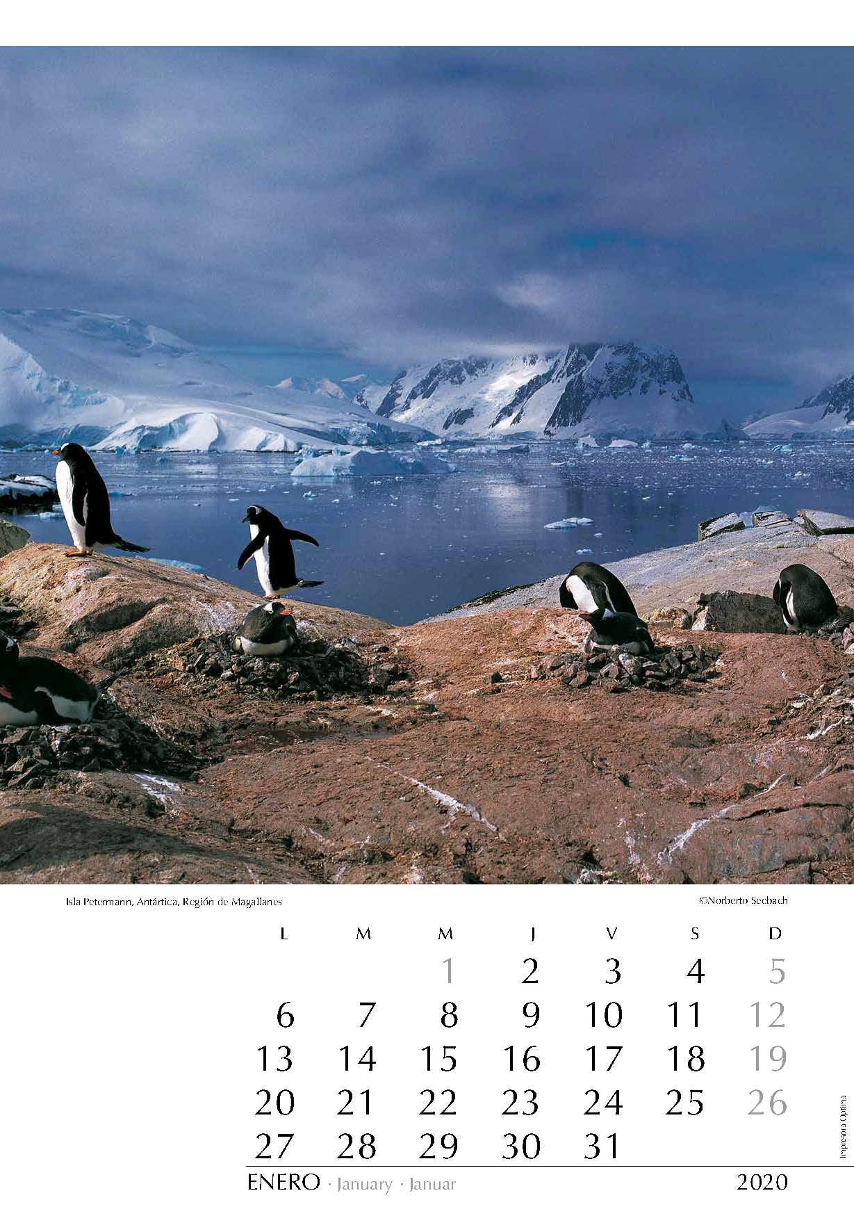
ENERO
Isla Petermann, Antártica
Región de Magallanes
Entre los más australes puntos de recalada del creciente número de cruceros que navegan por la costa occidental de la península antártica figura la isla Petermann, descubierta por una expedición alemana en 1873-1874. Se encuentra en el paralelo 65 y tiene unos 2 km de largo. Desde la orilla en que anidan y pasean graciosamente estos pingüinos Juanito o Papúa (Pygoscelis papua) se reconocen hacia el norte la isla Booth y el ingreso al canal Lemaire.
Among the southernmost points of call of the increasing number of cruise ships navigating along the west coast of the Antarctic Peninsula appears the Petermann island, discovered by a German expedition in 1873-1874. It is located on the parallel 65 and about 2 km long. From the shore where these Gentoo penguins (Pygoscelis papua) nest and walk gracefully, you can recognize in northerly direction Booth Island and the entrance to the Lemaire Channel.
Zu den südlichsten Anlaufstellen der zunehmenden Anzahl von Kreuzfahrtschiffen, die entlang der Westküste der Antarktis navigieren, zählt die Insel Petermann. Sie wurde von einer deutschen Expedition in 1873-1874 entdeckt. Sie liegt auf dem 65. Breitengrad und ist etwa zwei Kilometer lang. Vom Ufer aus, an dem Eselspinguine (Pygoscelis papua) nisten und anmutig daherschreiten, erkennt man in nördlicher Richtung die Insel Booth und die Einfahrt in die Lemaire-Straße.
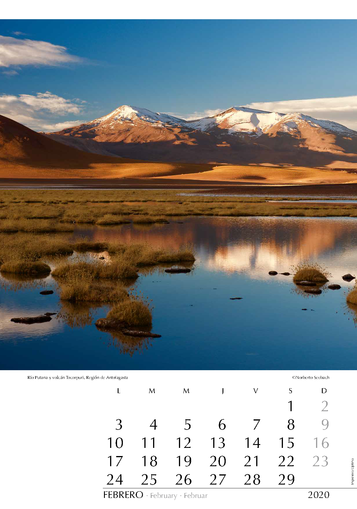
FEBRERO
Río Putana y volcán Tocorpuri
Región de Antofagasta
El volcán Tocorpuri (5810 m) se ubica en el altiplano de Antofagasta en la frontera con Bolivia. El cruce del río Putana, que corre aquí sobre los 4000 m y distante unos 60 km al norte de San Pedro de Atacama, complicaba, sobre todo con nieve, el acceso a los géiseres del Tatio, ubicados unos 25 km al norte de este lugar. El mejoramiento del camino a lo largo de los años y la construcción de un vado permiten hoy recibir de mejor manera el constante aumento de turistas que visitan el sector.
The Tocorpuri Volcano (5810 m) is located in the Altiplano of Antofagasta and on the border with Bolivia. Crossing the Río Putana, that runs here at over 4000 m, and some 60 km north of San Pedro de Atacama, could difficult the access, particularly with snow, to the Tatio Geysers located some 25 km north of here. The improvement of the road over the past few years and the construction of a ford make it easier nowadays to welcome the constantly increasing number of tourists that visit the area.
Der Tocorpuri Vulkan (5810 m) befindet sich im Andenhochland Antofagastas auf der Grenze mit Bolivien. Die Überquerung des Río Putana, der sich auf über 4000 m auf dem Gebirge entlang schlängelt, etwa 60 km nördlich von San Pedro de Atacama, war vor allem mit Schnee ein ernsthaftes Hindernis auf dem Weg zu den Tatio Geysiren, von hier aus noch weitere 25 km Richtung Norden. Die Verbesserung der Straße und der Bau eines Furts erlauben heutzutage einen einfacheren Zugang für die stets wachsende Anzahl von Touristen in der Gegend.
MARZO
Puerto Varas
Región de los Lagos
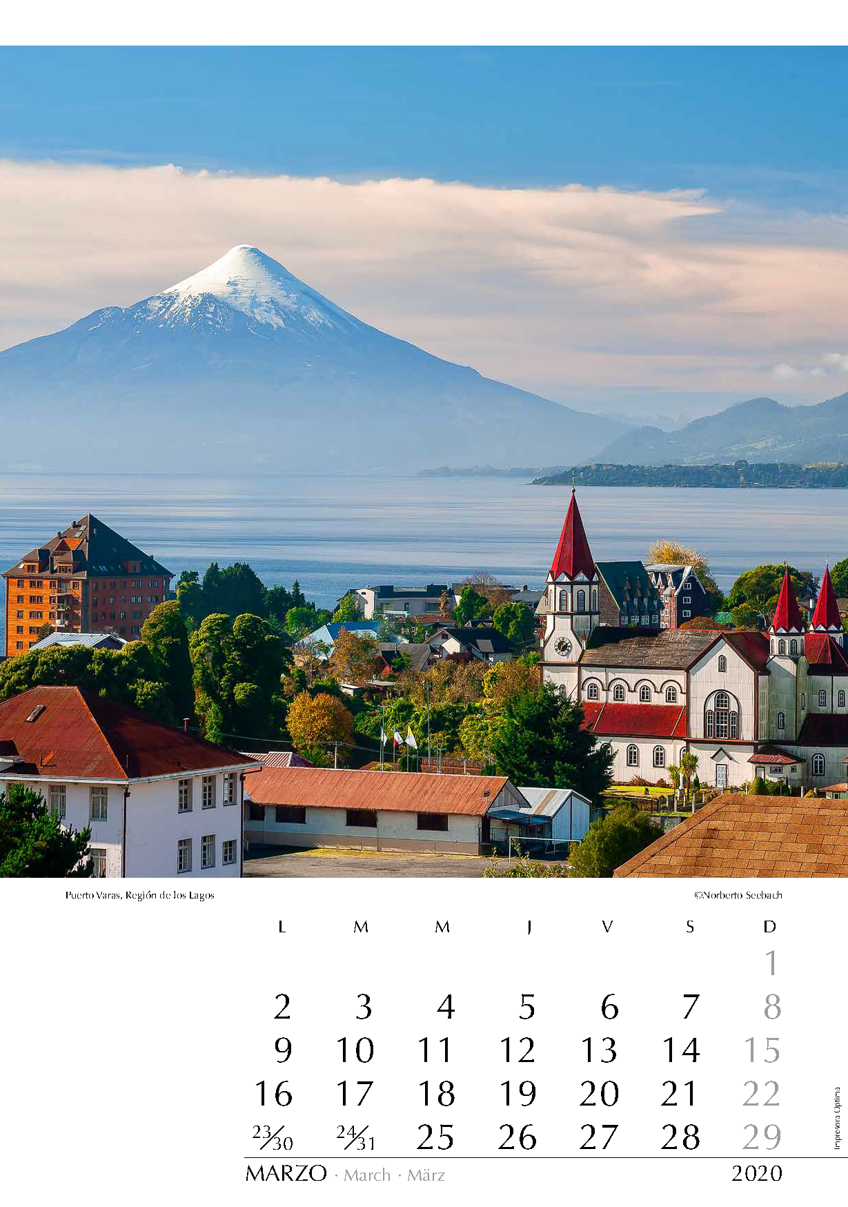
El lago Llanquihue (860 km2) y el volcán Osorno (2700 m) con frecuencia se asocian a la colonización alemana que se inició en 1850. Ya en 1880, prácticamente todas las riberas del lago estaban parceladas. Antaño fue surcado por vapores que comunicaban los diversos asentamientos. Hoy hay caminos por todas las orillas; y junto a las tradicionales viviendas, aparecen también todo tipo de casas de veraneo, que se ubican para disfrutar el hermoso telón de fondo formado por los volcanes andinos. La ya centenaria iglesia del Sagrado Corazón de Jesús en Puerto Varas, en el centro de la imagen, constituye un símbolo para esta ciudad lacustre fundada en 1854.
The Llanquihue Lake (860 km2) and the Osorno Volcano (2700 m) are often associated with the German colonization that started in 1850. By 1880, virtually the whole region around the lake was divided into lots. Once crossed by steamers connecting the different populations, nowadays there are roads all along the shores; and together with the traditional houses, many vacation houses appear to enjoy the outstanding view of the Andean peaks. The centenary Church of Sagrado Corazón de Jesús in Puerto Varas, in the center of the image, constitutes a symbol for this lake city founded in 1854.
Der Llanquihue-See (860 km2) und der Vulkan Osorno (2700 m) werden oft mit der deutschen Einwanderung, die etwa ab Mitte des 19. Jahrhunderts begann, in Zusammenhang gebracht. Schon 1880 waren nahezu alle Landstriche um den See parzelliert. Dampfer sorgten damals für die Verbindung zwischen den einzelnen Ansiedlungen. Heute sind sämtliche Ufer durch Straßen erschlossen und neben den traditionellen Häusern entstanden vielerorts Ferienhäuser um die Aussicht auf die Andengipfel zu genießen. Die bereits hundertjährige Kirche des Sagrado Corazón de Jesús in Puerto Varas ist ein Wahrzeichen dieser Seestadt.
ABRIL
Bahía Apolillado
Región de Atacama
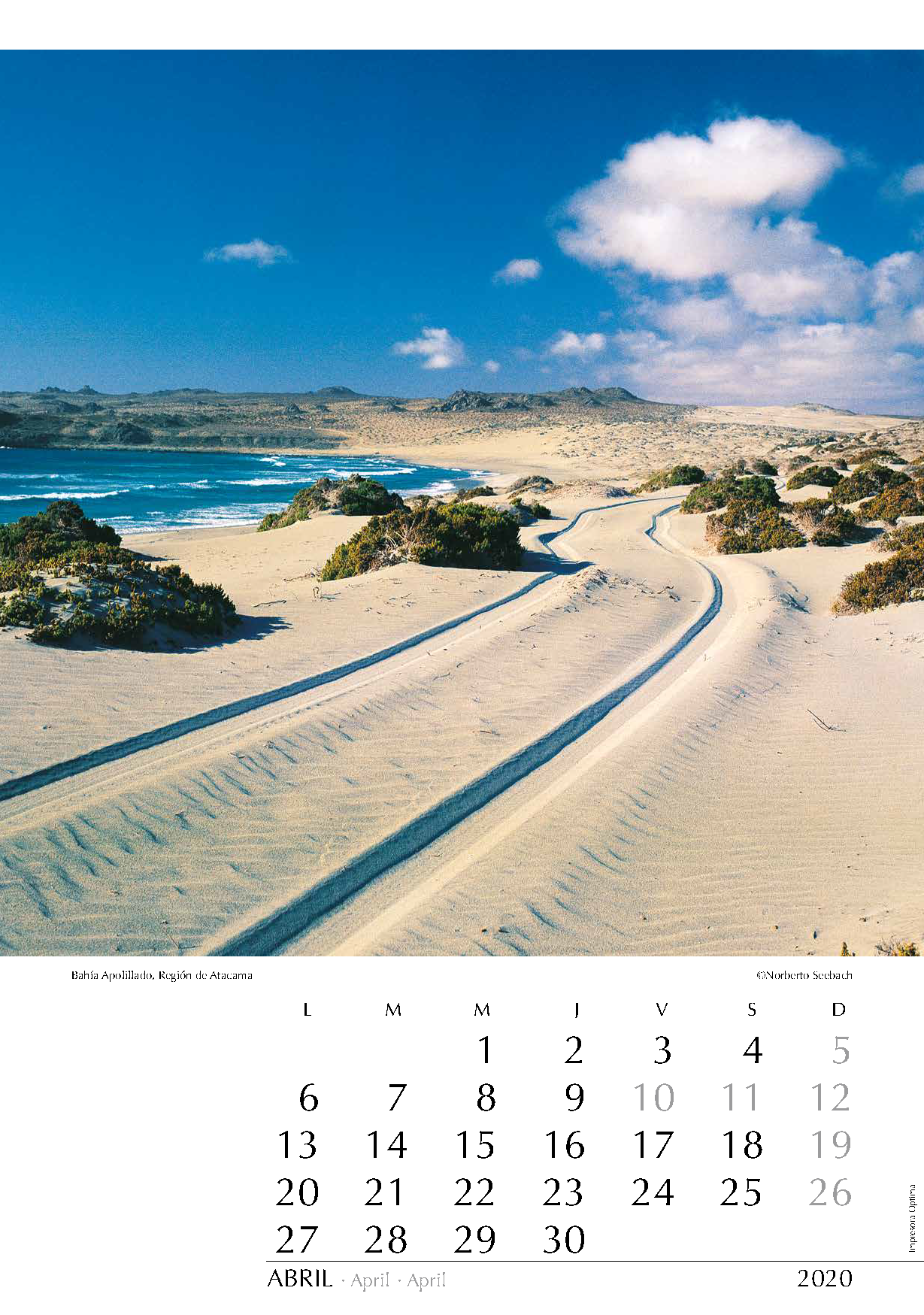
Con varios miles de kilómetros de litoral, Chile ofrece una variedad difícilmente superable de escenarios. La costa en esta zona es en su mayor parte rocosa, bastante accidentada y escasa en vegetación. La falta de una buena ruta costera y la escasez de recursos de agua dulce han impedido el desarrollo de poblados mayores. El Pacífico a menudo embravecido azota con frecuencia esta costa que, además de modestas caletas, ofrece solitarias playas como esta en Bahía Apolillado, justo en el límite interregional Atacama-Coquimbo.
With its several thousand miles of littoral, Chile provides a hardly surpassing variety of sceneries. The coast in this area is mostly rocky, quite rugged and sparse in vegetation. The lack of a good coastal route in this sector and the scarcity of fresh water resources have prevented the development of larger settlements. The often-enraged Pacific lashes the coast that, in addition to modest coves, offers lonely beaches like the one shown here at Bahía Apolillado, exactly on the border of the Atacama and Coquimbo Regions.
Mit einigen Tausend Kilometern Küste bietet Chile eine wohl schwer zu übertreffende Vielfalt an Naturszenarien. In dieser Zone ist die Küste meist felsig, oft zerklüftet und vegetationsarm. Das Fehlen einer guten Küstenstraße in diesem Abschnitt und die Wasserknappheit sind Hindernisse für die Entstehung von größeren Siedlungen. Der häufig tobende Pazifik peitscht gegen das Meeresufer; neben bescheidenen Fischerdörfern stößt man auf einsame Strände wie den abgebildeten in Bahía Apolillado, genau an der Regionalgrenze zwischen Atacama und Coquimbo.
MAYO
Valle Aconcagua
Región de Valparaíso
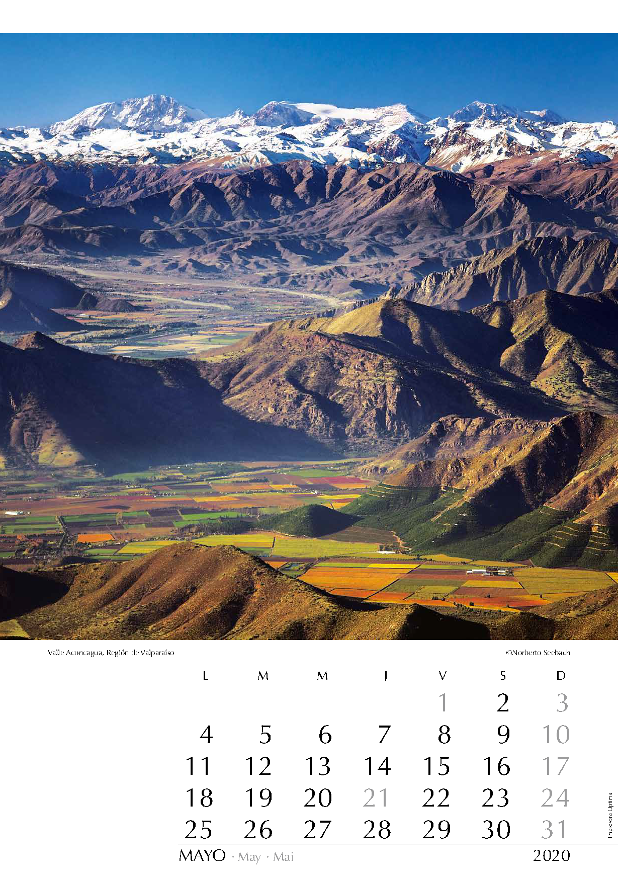
El río Aconcagua que desciende entre los más australes cordones transversales, marca el inicio del Chile Central. Las planicies de su valle albergan cultivos hortofrutículas que constituyen una importante fuente alimentaria para el país, además de significativos aportes como bienes de exportación. Desde el cerro El Roble (2210 m) se ve el valle de Putaendo y en el macizo andino destaca el cerro Mercedario cuya cumbre de 6770 m está en Argentina.
Descending through the southernmost east-west mountain chains, Río Aconcagua marks the beginning of Central Chile. The intensively cultivated plains of the valley produce an important food supply for the country’s inhabitants and a significant contribution as exported products. From the Cerro El Roble (2210 m) you can see the Valley of Putaendo and in the Andean Range highlights Cerro Mercedario whose 6770 m summit is in Argentina.
Zwischen den südlichsten Ost-West-Ausläufern der Andenkette schlängelt sich der Río Aconcagua und markiert den Beginn der sog. Zentralzone Chiles. In den intensiv genutzten Ebenen des Tales gedeiht Obst und Gemüse, das wesentlich zur Nahrung des Landes beiträgt und dessen Export wichtige Devisen einbringt. Vom Cerro El Roble (2210 m) aus blickt man auf das Tal von Putaendo; in den Anden ragt der Cerro Mercedario hervor. Sein 6770 m hoher Gipfel befindet sich in Argentinien.
JUNIO
Camino a Yendegaia
Región de Magallanes
La isla grande de Tierra del Fuego, compartida con Argentina, es sinónimo de grandes aventuras, de tierras extensas e inhóspitas. En 1920, a ambos lados de la frontera había igual cantidad de habitantes; hoy la relación es de 1 (Chile) a 20 (Argentina). La parte norte de la isla es plana y muy venteada. Seguramente tomará todavía un par de años hasta que se logre terminar la ruta transfueguina, que debe sortear diversos cordones montañosos anexos a la Cordillera Darwin para alcanzar el canal Beagle. En la imagen, un tramo de esta ruta al norte del lago Deseado.
The main Island of Tierra del Fuego, shared with Argentina, is synonymous with great adventures and inhospitable vast open spaces. In 1920, on both sides of the borderline, there was an equal number of inhabitants; nowadays the ratio is 1 (Chile) to 20 (Argentina). The northern part of the island is flat and very windy. Surely, it will still take a couple of years until the trans-Fuegian route will be concluded in its southern extreme; several mountain ranges annexed to the Cordillera Darwin have to be overcome before the Beagle Channel is reached. In the image, a stretch of this route north of Lake Deseado.
Die mit Argentinien geteilte Insel Feuerland steht bei vielen für große Abenteuer und unendliche, ungastliche Weiten. 1920 gab es auf beiden Seiten der Grenze etwa gleich viel Einwohner, heute beträgt das Verhältnis 1 (Chile) zu 20 (Argentinien). Der nördliche Teil Feuerlands ist eben und windig. Es wird sicherlich noch ein paar Jahre dauern bis die Ruta Transfueguina im südlichen Teil vollendet wird. Jene Nordsüdachse durch Feuerland muss mehrere an die Cordillera Darwin angeschlossene Bergketten überwinden, um den Beagle- Kanal zu erreichen. Auf dem Bild, ein Abschnitt dieser Route nördlich vom Lago Deseado.
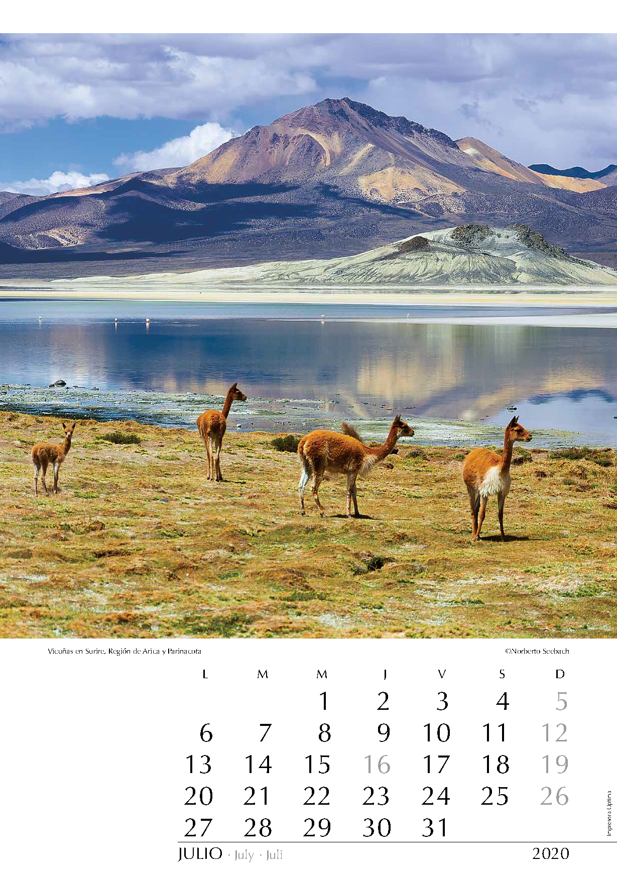
JULIO
Vicuñas en Surire
Región de Arica y Parinacota
En pleno Altiplano al sureste de Arica y muy próximo a la frontera boliviana, se localiza, a más de 4000 m de altitud, el más septentrional de los grandes salares del Norte Grande. Se puede acceder desde Iquique (300 km) o desde Arica (280 km). En el salar se puede observar una variada fauna: vicuñas, flamencos, patos y, por cierto, también los suris o ñandúes de la puna, aves parecidas a las avestruces, que han dado el nombre a este lugar. En la imagen se aprecian vicuñas pastando en primer plano y algunos flamencos en el agua más atrás.
Close to the Bolivian border in the Altiplano southeast of Arica lies the northernmost salt lake of the “Norte Grande” at an altitude of more than 4000 m. It can be reached either from Iquique (300 km) or from Arica (280 km). Attractive fauna can be
observed here: vicuñas (a camelid), flamingoes, ducks and even suris, or ñandúes of the Puna, which are a kind of bird similar to the ostrich, and which gives this place its name. On the foreground one can see vicuñas and some flamencos in the water.
Inmitten des Altiplano südöstlich von Arica und nahe der Grenze zu Bolivien stößt man auf den über 4000 m über dem Meeresspiegel gelegenen Salar de Surire. Die Zufahrt ist sowohl von Iquique (300 km) wie auch von Arica (280 km) aus möglich. Hier kann man eine reichhaltige Tierwelt beobachten: Vicuñas (eine Lamaart), Flamingos, Enten und Suris oder Ñandúes der Puna, eine Vogelart, die dem Strauß ähnelt. Daher kommt auch der Name des Salzsees. Auf der Aufnahme sieht man Vicuñas im Vordergrund und einige Flamingos im Wasser.
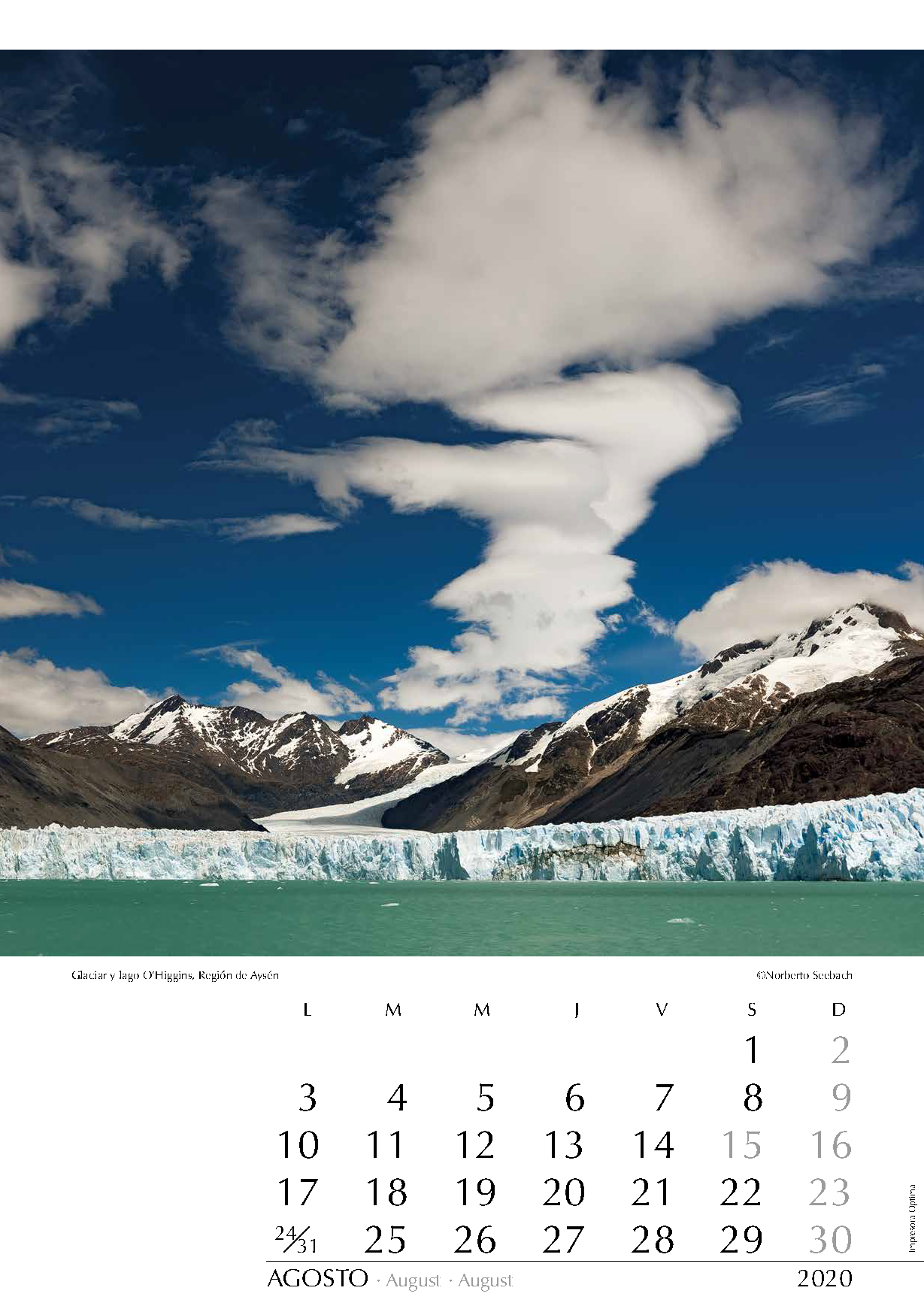
AGOSTO
Glaciar y lago O’Higgins
Región de Aysén
En los hielos que cubren los Andes australes se originan los glaciares que descienden a los fiordos del Pacífico y a los grandes lagos patagónicos, tanto chilenos como argentinos. Uno de los mayores glaciares en Aysén es el O’Higgins, que vierte sus témpanos en el lago homónimo (en Argentina se denomina San Martín). Hasta 1995 este glaciar registró uno de los más significativos retrocesos en toda el área. Hoy en día se ha facilitado el acceso: embarcando cerca de Villa O’Higgins, unas cuatro horas de navegación por el a menudo agitado lago conducen a este remoto lugar.
The glaciers descending into the fjords of the Pacific Ocean and into the great Patagonian lakes in Chile as well as in Argentina originate from the ice fields covering the South Andean Range. One of the greatest glaciers in Aysén is Glaciar O’Higgins whose icebergs dip into the lake by the same name (called San Martín in Argentina). Until 1995, this glacier registered one of the most significant setbacks in the whole area. Nowadays the access has been facilitated: Taking a boat near Villa O’Higgins, an about-four-hours navigation on the often-agitated lake leads to this remote place.
Von den Eisfeldern, welche die Süd-Anden bedecken, entstehen die Gletscher, die in die Fjorde des Pazifiks und in die großen Seen Patagoniens, sowohl in Chile wie auch in Argentinien, gleiten. Eines der größten Gletscher in Aysén ist Glaciar O’Higgins, dessen Eisberge in den gleichnamigen See stürzen (in Argentinien San Martín benannt). Bis 1995 hat dieser Gletscher im gesamten Gebiet den größten Rückgang gezeigt. Heutzutage ist der Zugang zu diesem Ort erleichtert worden: nachdem man nahe von Villa O’Higgins auf ein Boot steigt, erreicht man nach einer etwa vierstündigen Navigation auf dem oft bewegten See diesen entlegenen Ort.
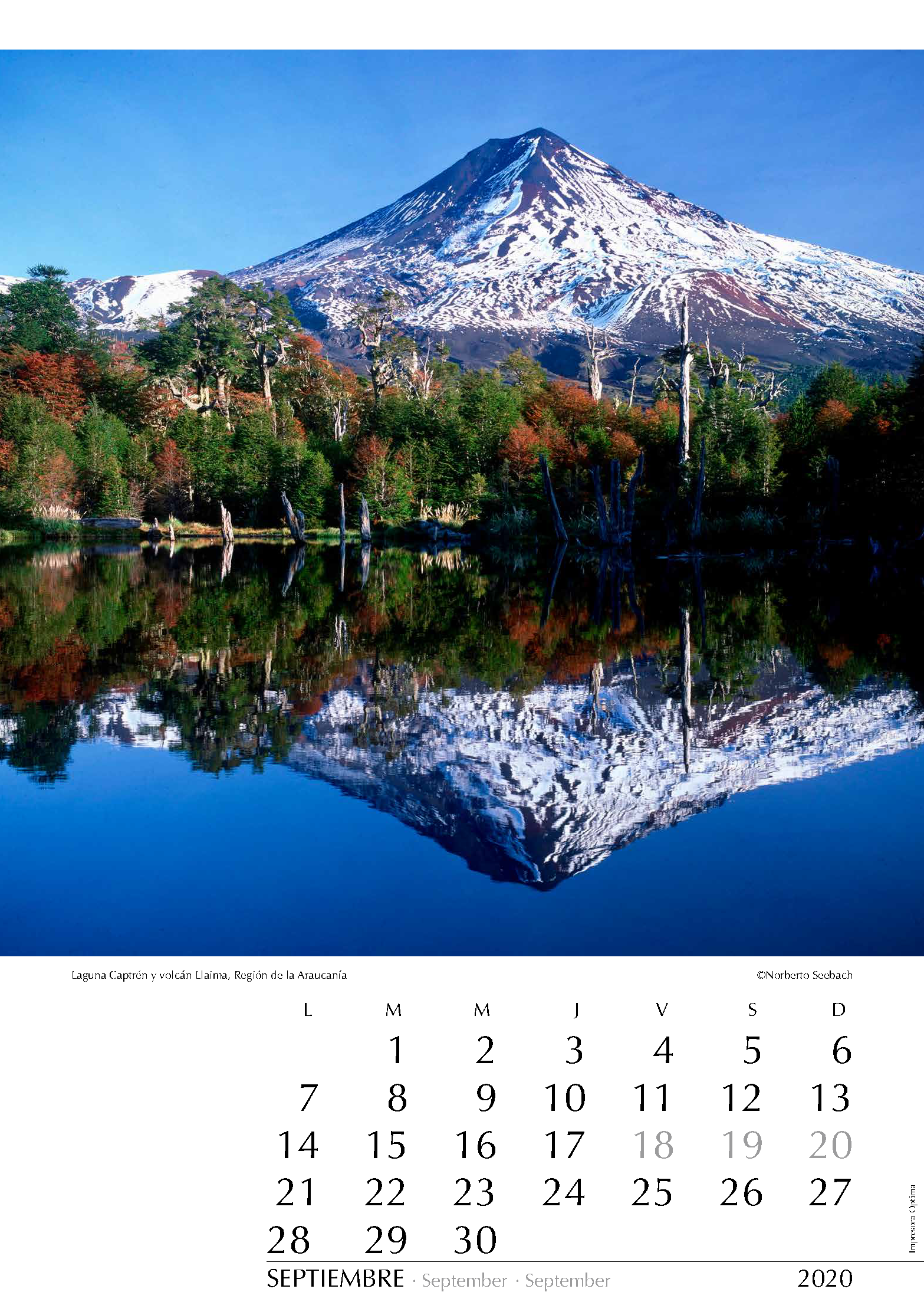
SEPTIEMBRE
Laguna Captrén y volcán Llaima
Región de la Araucanía
Cubriendo cerca de 600 km2 en el macizo andino, 130 km al este de la ciudad de Temuco, se ubica el Parque Nacional Conguillío. Por sus múltiples atractivos escénicos, junto a una interesante y variada flora y fauna, es uno de los más visitados del sur de Chile. En las aguas de la laguna Captrén se refleja el inquieto volcán Llaima (3120 m). Es tal vez el más representativo de los volcanes de la Región de la Araucanía y, junto al Villarrica, uno de los más activos del país. Su cráter permanece activo y es frecuente verlo humear. Por su relativo aislamiento del macizo andino, se le ve desde gran distancia.
Covering nearly 600 km2, the Conguillío National Park is located in the Andean Range and 130 km east of Temuco. Due to the numerous scenic attractions, including an interesting and diverse flora and fauna, it is one of the most visited parks in southern Chile. The Llaima Volcano (3120 m) is probably the most representative volcano in the Araucanía Region and, together with the Villarrica, one of the most active in the country. It is the main attraction of the national park. The still active crater is frequently smoking. Relatively isolated from the Andean Range, the Llaima can be well seen from afar.
Der 130 Kilometer östlich von Temuco gelegene Nationalpark Conguillío umfasst über 600 km2 des Andenmassivs. Dank der Vielfalt schöner Landschaften mit ihrer
interessanten und abwechslungsreichen Flora und Fauna zählt der Park zu den meistbesuchten Südchiles. Der 3120 m hohe Volcán Llaima ist der wohl bedeutendste Vulkan in der Region Araucanía und ist, zusammen mit dem Villarrica, einer der aktivsten im Lande. Er ist der Mittelpunkt des Nationalparks. Sein Krater ist stets aktiv, und häufig sieht man den Berg rauchen. Da er der Andenkette vorgelagert ist, sieht man ihn von weitem.
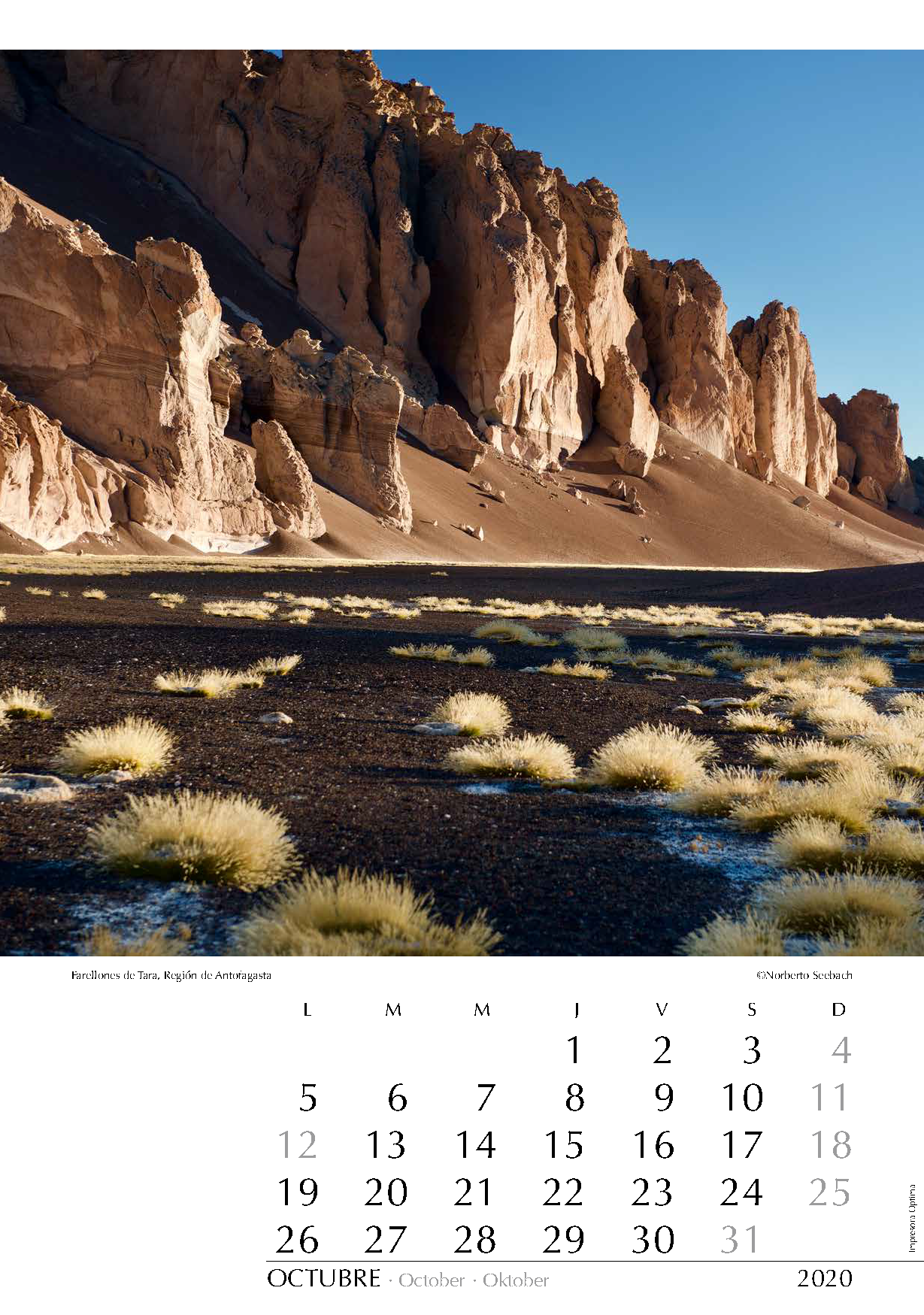
OCTUBRE
Farellones de Tara
Región de Antofagasta
En el altiplano de Antofagasta, tras avanzar unos 100 km desde San Pedro de Atacama al oriente en la ruta a Argentina por el paso de Jama, se puede abandonar dicho camino hacia el nororiente para seguir por aventuradas huellas hasta el salar de Tara. El paisaje agreste que lo rodea presenta interesantes formaciones rocosas con farellones erosionados por la fuerza eólica.
Going east from San Pedro de Atacama and following the route to Argentina (Jama Pass) for about 100 km, one can leave the road towards the northeast and venture along dirt tracks before reaching Tara Salt Lake. The wild landscapes surrounding Tara Salt Lake on the Altiplano of the Region of Antofagasta offer strangely shaped cliffs formed by wind erosion.
Begibt man sich von San Pedro de Atacama aus auf den Weg nach Argentinien (Jama Pass), so kann man nach etwa 100 km Fahrt durch das Altiplano Antofagastas abenteuerliche Spuren Richtung Nordosten vorfinden, die bis zum Salar Tara führen. An seinen Ufern stößt man auf interessante, durch Wind erodierte Felswände.
NOVIEMBRE
Litoral en La Mostaza
Región de Valparaíso
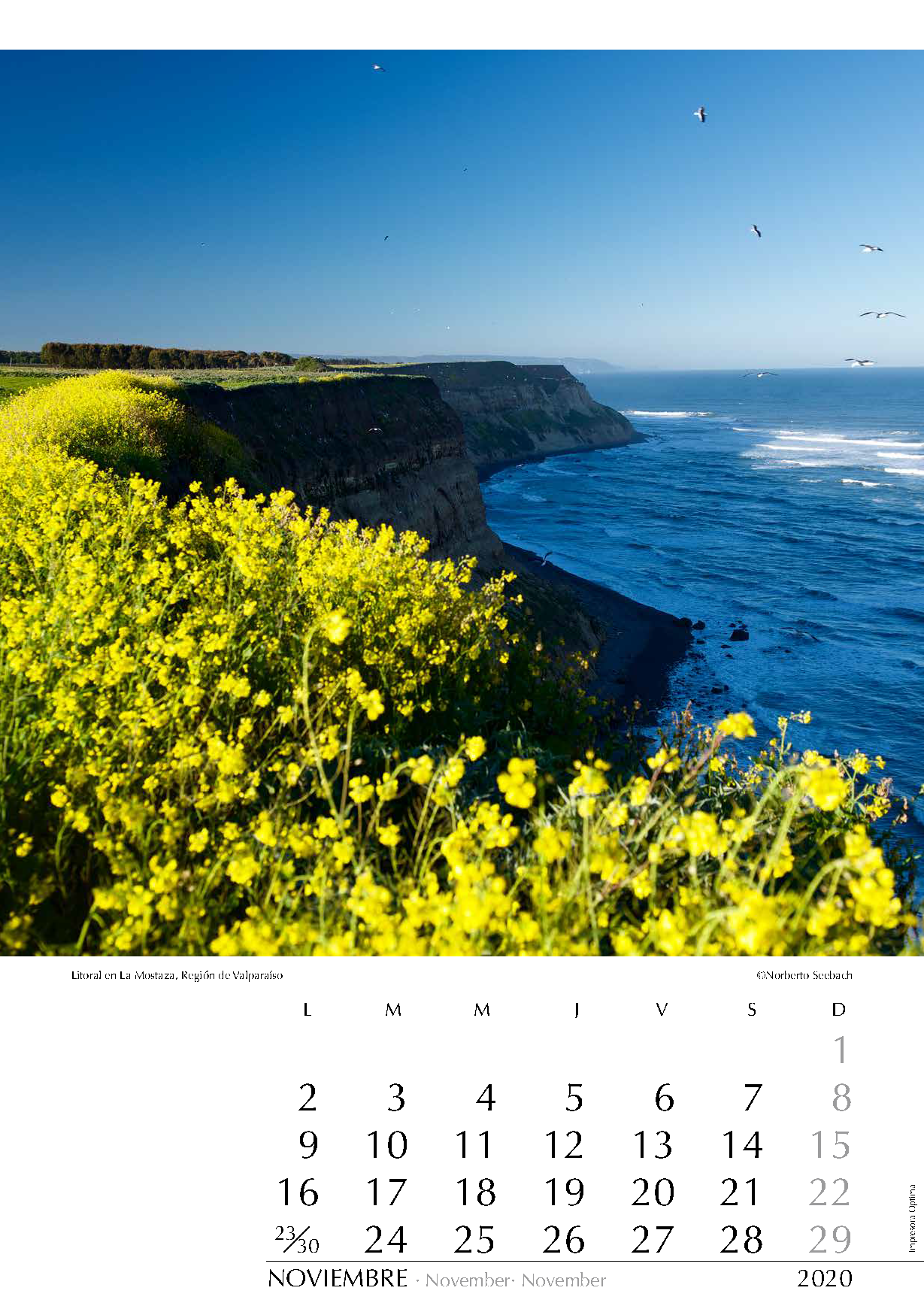
El litoral del Chile central, sobre todo desde la Región de Valparaíso al sur, ha tenido un marcado auge en las últimas décadas. Cada vez son más los que escapan del mundanal ruido de la capital, a tan solo 160 km de distancia, ya sea por el fin de semana o temporadas más extensas. Este lugar, conocido como La Mostaza, muestra en primavera un poco de esos “campos bordados de flores”, tal como reza el himno nacional. Tan solo un par de kilómetros más al sur está la desembocadura del río Rapel, límite interregional entre Valparaíso y O’Higgins.
The coast of Central Chile, particularly from the Valparaíso Region to the south, has shown an impressive boom in the last few decades. More and more people are fleeing from the clamor of the capital, located only 160 km away, either for the weekend or for longer periods. This place is known as La Mostaza and shows in spring “meadows embroidered with flowers”, as the national anthem says. Only a few kilometers south is the mouth of Río Rapel, the border between the regions of Valparaíso and O’Higgins.
Das Küstengebiet von Zentralchile hat in den letzten Jahrzenten einen starken Boom erlebt, vor allem von der Valparaíso Region Richtung Süden. Immer mehr Besucher flüchten vom Lärm der Hauptstadt, die hier etwa 160 km entfernt ist, sei es für das Wochenende oder für längere Zeit. Dieser Ort wird La Mostaza bezeichnet und zeigt im Frühling "mit Blumen bestickte Felder“, wie die Nationalhymne sagt. Nur einige km südlich befindet sich die Mündung vom Río Rapel, die interregionale Grenze zwischen Valparaíso und O’Higgins.
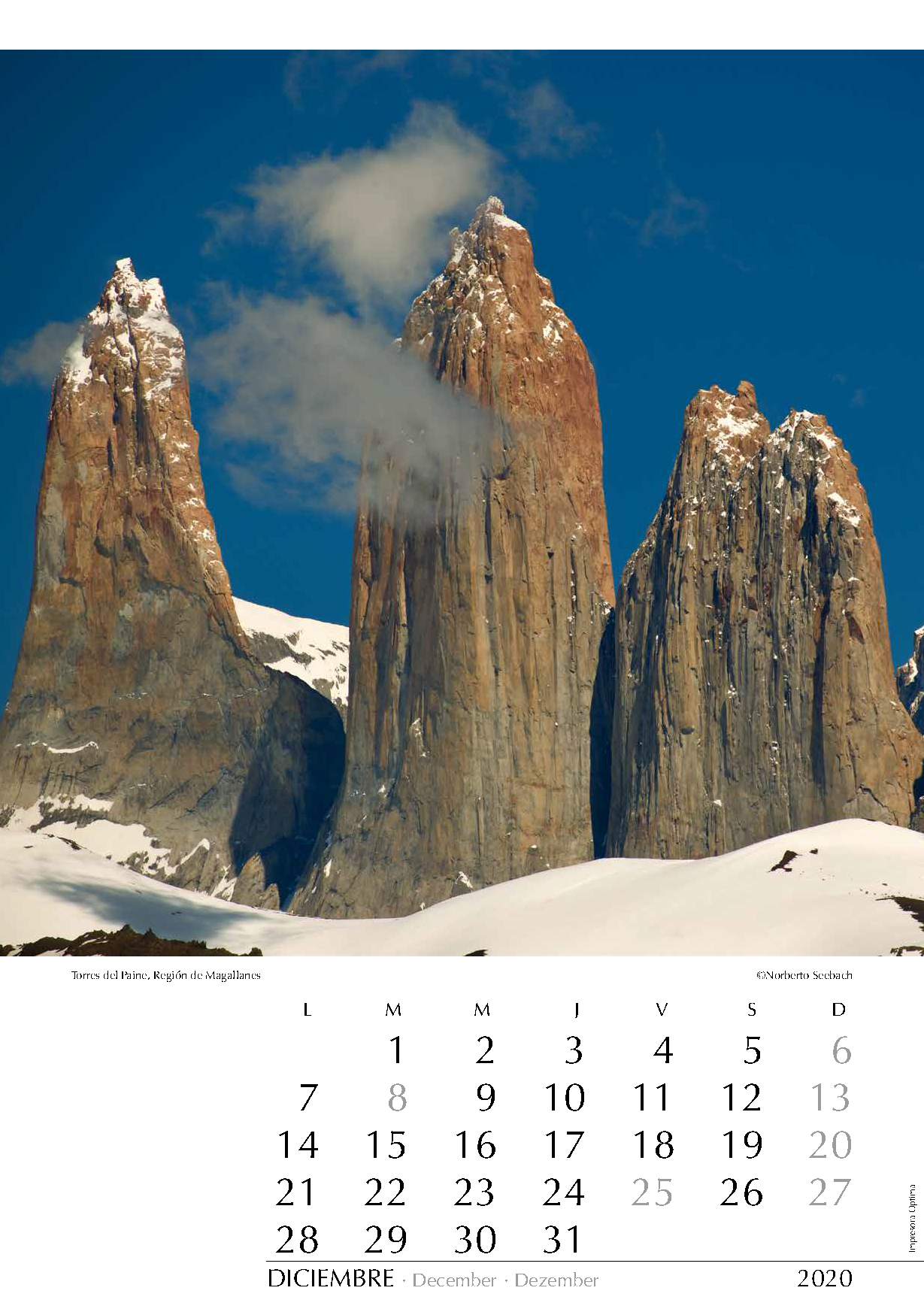
DICIEMBRE
Torres del Paine
Región de Magallanes
El Parque Nacional Torres del Paine reúne tal vez los más espectaculares y hermosos paisajes de Chile. Cada año es mayor el número de visitantes que acceden a estos parajes de la Patagonia, ubicados cerca de 400 km al norte de Punta Arenas. Sus cumbres desafían a montañistas de todo el mundo. En la fotografía se aprecian las moles graníticas que dan nombre al parque (de izquierda a derecha): la Torre Sur o D’Agostini (2850 m), la Torre Central (2800 m) y la Torre Norte (2600 m).
Torres del Paine National Park boasts perhaps the most spectacular and stunning scenery of all Chile. The number of visitors reaching this Patagonian spot located close to 400 km north of Punta Arenas increases every year. Its peaks are a challenge for climbers from all over the world. On the photograph, one can see the granitic moles that give the park its name (from left to right): the Torre Sur or D’Agostini (2850 m), Torre Central (2800 m) and Torre Norte (2600 m).
Der Nationalpark Torres del Paine birgt wahrscheinlich die spektakulärsten Landschaften Chiles. Die Anzahl der Besucher dieser etwa 400 km nördlich von Punta Arenas gelegenen Stätte Patagoniens wächst von Jahr zu Jahr. Die Gipfel sind eine Herausforderung für Bergsteiger aus aller Welt. Auf dem Foto sieht man die Granitsäulen, die dem Park seinen Namen geben (von links nach rechts): Torre Sur oder D’Agostini (2850 m), Torre Central (2800 m) und Torre Norte (2600 m).